FOR IMMEDIATE RELEASE
October 29, 2024
Media Contacts:
Chloe Miller, Green Mountain Club Communication Manager,
, (907) 632-7405
Jon Reidel, Middlebury College Director of Media Relations,
, 802-443-4208
Middlebury College Grants Trail Right-of-Way to Green Mountain Club
1.5 miles of Long Trail permanently protected
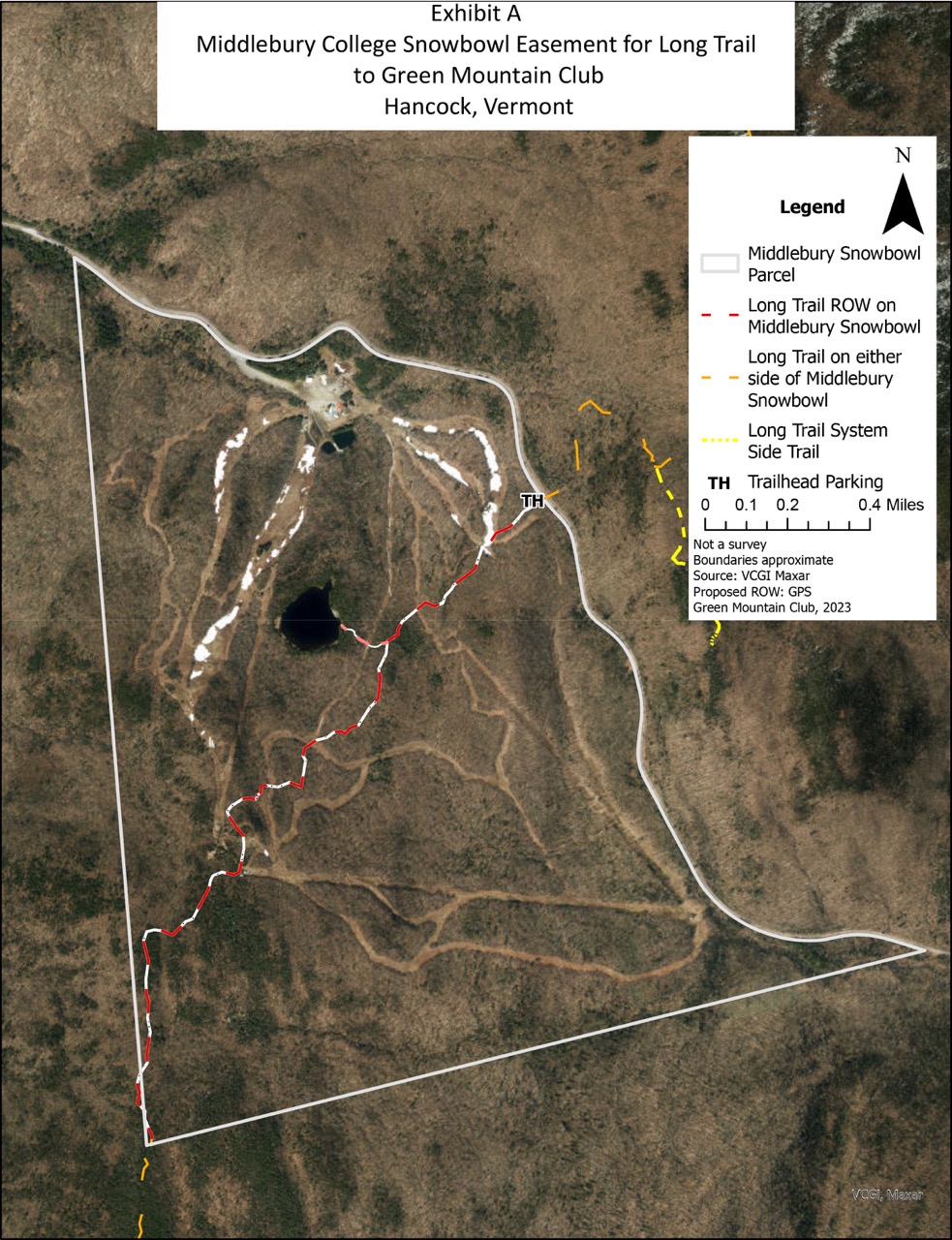
WATERBURY, VT – Middlebury College has donated a trail right-of-way to the Green Mountain Club that permanently protects 1.5 miles of Long Trail treadway.
This trail right-of-way protects the longest remaining section of privately owned Long Trail treadway. Its donation brings the total miles of unprotected Long Trail down to just 4.5 miles, or 2% of the Long Trail. Since 1986 the Green Mountain Club has been seeking permanent protection for the Long Trail and its surrounding lands, and the donation by Middlebury is a significant step forward toward achieving that goal.
“The Green Mountain Club is tremendously grateful to Middlebury College for their donation of a trail right-of-way to protect the Long Trail. Generous and supportive landowners like Middlebury College are what have made the Long Trail possible for 114 years. We couldn’t have Vermont’s hiking trails without them and GMC is excited to be deepening our partnership with the College through this trail right-of-way,” said Mike DeBonis, GMC Executive Director.
The 272-mile Long Trail is a long-distance hiking trail that runs the length of Vermont from Massachusetts to Canada, along the spine of the Green Mountains. It was conceived in 1910, served as the inspiration for the Appalachian Trail and, along with its side trails, provides 500 miles of hiking trails in Vermont. The Long Trail draws thousands of locals and visitors each year and provides economic and wellness benefits for local communities. Permanent protection of the Long Trail will ensure that hikers and communities continue to have access to and benefit from this incredible recreation asset.
“Middlebury College’s century-long partnership with the Green Mountain Club is a shared commitment to preserving land for the public good,” said President Laurie L. Patton. “We’re pleased to help ensure that access to the storied Long Trail—and its enjoyment by our entire community—will continue into the future.”
Since it was first constructed in the 1910s, the Long Trail has crossed the property that is now Middlebury Snowbowl. The route of the LT by Pleiad Lake and up Worth Mountain is first depicted in the Green Mountain Club’s 1920 Long Trail Guide. Middlebury College was granted the land from Joseph Battell in 1916 and the first downhill ski trails were cut in 1934, making the Snowbowl one of Vermont’s earliest ski areas.
###
About Green Mountain Club
Established in 1910 to build the Long Trail, the Green Mountain Club is a private non-profit organization with over 9,800 members. GMC is dedicated to maintaining and protecting Vermont’s historic Long Trail, Appalachian Trail in Vermont, and the Kingdom Heritage Lands trails in the Northeast Kingdom. Every year more than 1,000 volunteers work so that current and future generations will enjoy the 500-mile Long Trail System. Contact the Green Mountain Club to learn more about the GMC or to become a member.
About Middlebury CollegeMiddlebury is an undergraduate college; a graduate school for international studies; a home for immersive language study; a graduate school for the study of literature, literacy, and pedagogy; a leader of schools abroad sites that span the globe; and a home for the oldest and most prestigious writers’ conference in the world, which has spawned conferences in environmental writing and translation as well.
FOR IMMEDIATE RELEASE:CONTACT: Chloe Miller, Communications Manager at Green Mountain Club, , 907-632-7405
Kathryn Wrigley, Outdoor Recreation Specialist IV, Vermont FPR, , 802-871-0535
GREEN MOUNTAIN CLUB COMPLETES OVERHAUL OF HISTORIC CAMEL’S HUMP HIKING TRAIL
$700,000, three-year investment improves trail durability and longevity, hiker experience, and climate resiliency.
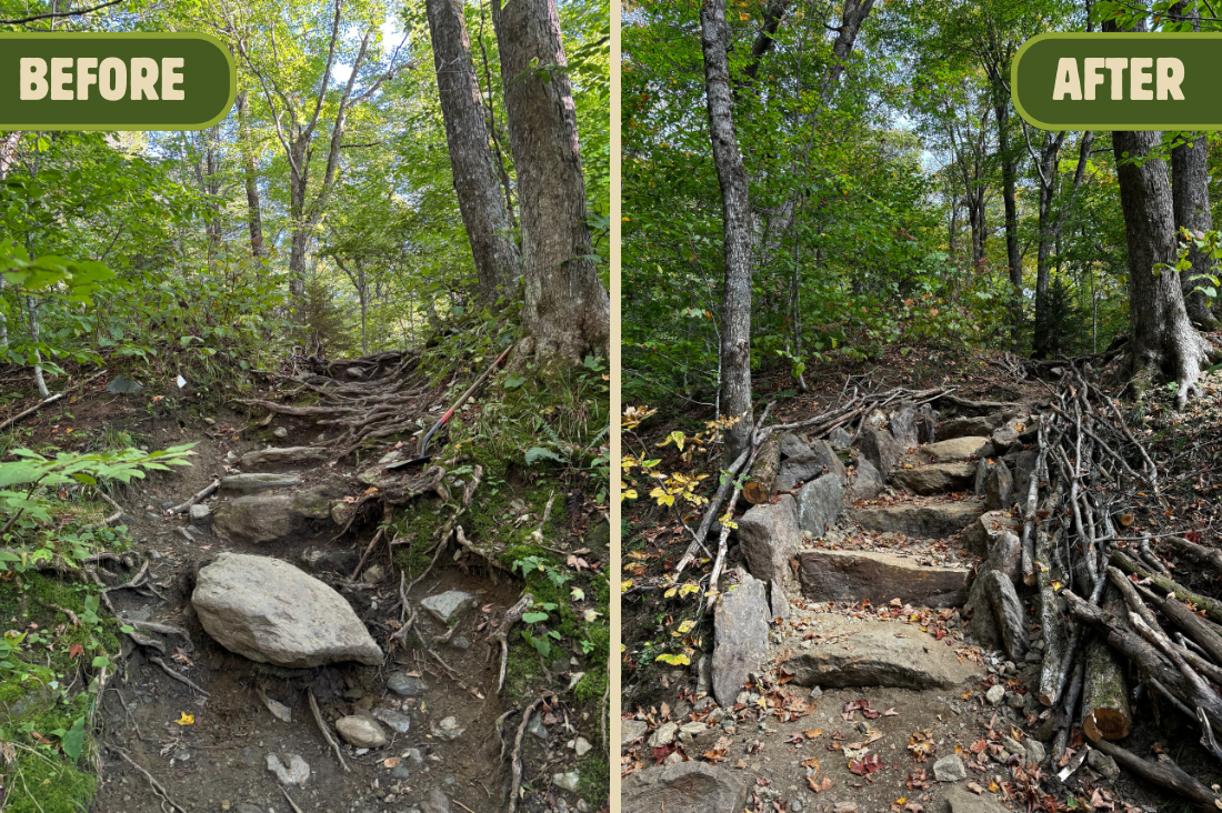
Huntington, Vermont – After 70 weeks of work over the past three years, the Green Mountain Club and Vermont Department of Forests Parks and Recreation (FPR) have completed a top-to-bottom rehabilitation project of the popular Burrows hiking trail on Camel’s Hump, the largest trail work project of its kind in Vermont’s modern history.
The Burrows Trail was built more than 100 years ago, before modern sustainable trail design standards existed. It’s one of the most-traveled hiking trails in the state, due to its proximity to Burlington and its relatively short distance to the summit of Camel’s Hump, one of Vermont’s highest peaks. Combined impacts of increased use, especially during the outdoor recreation boom of 2020, and erosion caused by more intense and frequent rainstorms exacerbated wear and tear on the trail to a point where GMC and FPR pursued a unique comprehensive approach to repairing the entire trail at once.
“Historically, due to limited funding and crew capacity, FPR and GMC have taken an ad-hoc, patch-it-up approach to trail work. But as the impacts of climate change become more apparent in Vermont, the Burrows Trail presented the opportunity to invest unprecedented funding and capacity and rebuild the whole trail at once,” said Keegan Tierney, GMC’s Director of Field Programs. “Even as repairs were in progress, we saw the improvements in action and how the trail was able to hold up to all three historic flooding events that Vermont was hit with in 2023 and 2024, with water draining off as intended and causing minimal erosion.”
Project planning started in 2018 and crews broke ground on the first of more than 300 identified sites on the 2.1-mile trail in June 2022. The project cost nearly $700,000, with funding sourced from FPR through a one-time allocation of State general funds designated specifically for outdoor recreation enhancements; FPR’s Enhancement of Recreation Stewardship and Access (ERSA) Grant fund, and private donors to The Green Mountain Club. GMC and FPR coordinated work between partners including the Vermont State Trail Crew, Vermont Youth Conservation Corps, Northwoods Stewardship Center, National Civilian Conservation Corps, and numerous volunteer groups.
“The Burrows Trail is visited and enjoyed by thousands of hikers each year, and is one of Vermont’s most popular recreational resources in every season. Thanks to our strong partnership with the Green Mountain Club, we were able to undertake such a comprehensive approach to repairing the trail, which will pay off for decades to come,” said Kathryn Wrigley, Outdoor Recreation Specialist, Vermont Department of Forests, Parks, and Recreation, who led scouting and planning efforts for the project.
Professionally skilled crews used mostly hand tools to repair and install hundreds of stone structures, like staircases, check steps and waterbars, to improve drainage and keep hikers on the intended path. The large-scale investment is designed to help the trail withstand increasingly frequent and severe precipitation and intensified year-round use.
The trail has remained open to the public throughout the project, and hikers will find an improved hiking experience from the trailhead to the trail’s intersection with the Long Trail. Crews used extensive revegetation practices to start the process of restoring the trail to its original natural state and maintain the natural feel of Vermont’s only undeveloped 4,000-foot summit. The project improves access to and the experience of hiking the Burrows Trail and solidifies its existence for decades to come.
Hiker Advisory:Burrows Trailhead to Long Trail Summit, 4.8 mi. round trip, 2,200 ft. elevation gain, difficult. Note that another popular trail to Camel’s Hump Summit, the Monroe Trailhead accessed from North Duxbury, is closed due to road damage and closure. We anticipate the Burrows Trail and trailhead will be quite crowded for the remainder of foliage season. If you plan to hike Burrows, consider visiting outside of peak hours. Always drive and park with respect for neighbors and do not block driveways or emergency access. If the parking lot is full when you arrive, consider a hike on this list of alternatives.
###
About the Green Mountain Club: The Green Mountain Club was founded in 1910 with one goal: to build a long-distance hiking trail that spans the length of Vermont’s mountains. The Long Trail was completed in 1930. Today, Green Mountain Club staff and volunteers care for roughly 500 miles of trail in Vermont, and take a sustainable approach to trail building and maintenance in the face of climate change impacts and increased year-round use of the trails. We support the hiking community with education and access to enjoy Vermont’s beloved trails.
This article appears in the 2024 Fall Long Trail News and was written by GMC’s Education and Volunteer Coordinator Lorne Currier.
Volunteerism is a long-established essential part of operations in the Green Mountain Club, particularly trail maintenance. Every mile of trail, every shelter, privy, white blaze or waterbar has either an individual or a group of Section volunteers responsible for it. Volunteers do most routine annual maintenance, and the Long Trail would fall into disrepair without them. If you are or have ever been a GMC volunteer, we thank you!
A History of Volunteerism
Volunteers cut the Long Trail from Massachusetts to Canada from 1910 to 1930, and they worked along with the paid Long Trail Patrol after its establishment in 1931. They ran all club operations until the first permanent employee was hired in 1973. Today full-time staff members work closely with volunteer leaders to reach our strategic goals.
The shelter adopter program began in 1980, followed by the trail and shelter adopter program in 1991, supplementing trail work that had always been section volunteers. Today nearly 200 adopters and 14 regional sections are the first line of defense for regular annual maintenance. They contributed more than 6,000 hours of work on more than 500 outings in 2023.
Until recently many adopters lacked personal connections with the GMC staff. They filled out requisite maintenance reports and sent them off into an apparent black hole. But given the increasing complexity of managing and maintaining trails, and the value of capable volunteers, the club saw a need for better training and communication for trail volunteers.
Increasing Trail Complexity
Climate change and evolving hiker use are greatly affecting trail conditions on the Long Trail System. Bigger and more frequent storms overwhelm waterbars and increase erosion. Mud season-like conditions can occur anytime. Invasive plants, wet heavy snow, and hurricanes, thunderstorms, tornados (!!) can fell hundreds of trees. Shorter winters with less snow invite more year-round use of the Long Trail, and more visits to undermaintained historically lower-use trails.
Twenty years ago, new adopters received trail or shelter assignments and a list of responsibilities, and were left to their own devices. A trail could survive with basic lopping of branches, removal of deadfalls, and blazing. Today, tread work and managing surface water and erosion are the volunteer’s most important job, and doing these tasks properly makes all the difference between trails that wash away in intense storms or effectively drain water off the trail and keep hikers on them.
New volunteers join sections or adopt a section of trail every season. And although many volunteers have more than 30 years of experience, trail maintenance standards and techniques evolve, and consistent training benefits everyone.
Increased Training for Volunteers
Kate Songer, front, joins the Bread Loaf section on a trail maintenance outing. Photo by Sara Quesnel.
Our guiding goal is to make each volunteer the best possible volunteer they can be. We do this via clear and regular communication, a standardized onboarding process for new volunteers, and enhanced opportunities for training in groups and one-on-one.
In 2017, GMC created a full time Volunteer and Education Coordinator position (held by me since 2019!). I quickly learned what limited support trail volunteers had, so we began to boost the onboarding and feedback process. In 2021 we added a seasonal staff position, currently Volunteer Supervisor Kate Songer. Kate joins adopters and sections in the field two or three times a week, offering hands-on instruction and developing “trail eyes.” We work with each volunteer to determine which projects to prioritize and how to do them well.
“The field training was essential,” recalled Michael Howson, a new adopter in 2024. “It gave me a greater appreciation of the work, what to look for and what is OK to do or not do. There is no way I would have been able to pick all that up from a manual or online presentation. I would not have expected that judicious trimming of branches is acceptable in a wilderness area or how to look for drainages other than water bars.”
Longtime adopters can learn new skills, too. Judy Raffone and her husband Robert, adopters of the LT between Forest Road 10 and Little Rock Pond, commented: “Though we’ve been maintainers for years, having a one-to-one learning experience was phenomenal, much better than a seminar or webinar. Kate introduced us to a better tool for cleaning water bars and we learned we could be more aggressive in our cleaning.”
Field training also instills a deeper investment in the volunteer role. As Kate explains it, “I love building a one-on-one human connection to other folks who care about the Long Trail System as much as I do. By spending time on the trail and talking with the volunteer about what maintenance it needs, we build a greater sense of stewardship and connection to the network of trails, volunteers, and crews.”
We also foster that connection with twice-annual all-adopter Zoom calls. Introduced during Covid, these are opportunities to meet and swap trail problems and successes. Communication continues in the field season as volunteers submit reports, and work with staff and other volunteers to meet challenges. No one person can maintain the entire Long Trail, but with our united workforce of staff and volunteers it becomes not only possible but successful.
Empowering Volunteers for Success
Volunteers Lisa and Mike do training with Kate Songer.
Dedicating GMC resources to support volunteers has moved us closer to our goal of making each volunteer the best they can be, and sets current and future volunteers up for success. Many volunteers, at GMC and elsewhere, skew on the older side. Volunteering for trail maintenance is easier with freedom from work, financial, and family responsibilities.
As these volunteers retire, adequate staff capacity is needed to support new volunteers. They may need loaner tools and multiple training outings. They may need smaller roles in order to balance life, work and volunteering. The commitment to supporting the development of skilled new volunteers now will pay dividends in decades to come.
Thank You
It would be remiss of me to omit an explicit note of appreciation to the volunteers who make it all happen, and to members and donors whose support enables our investments in volunteer programming. Next time you’re on the Long Trail, remember that every trail mile, shelter, or waterbar has a devoted volunteer. That has been the case for 114 years. With your support, I’m confident we’ll extend that streak another century or more.
This year marks the completion of a three-year backcountry construction boom at the Green Mountain Club. Paid crews and volunteers finished five new shelters, more than in any year since 1963. The average shelter has lasted about 30 years before wear, tear and damage made it inhabitable. But with better designs and standards we are dramatically increasingthe expected longevity of new shelters, which should serve hikers better and reduce repair needsin the long run.
Shelter Construction in 2023
Sunrise Shelter
[slideshow_deploy id=’17659′]
The new shelter is located 1.2 miles south of its previous site, and farther from the road. Site preparation, the foundation, piers, floor system and privy were completed in 2022. The GMC Special Projects Crew and volunteer Chip Swanson built the shelter in five working weeks in 2023.
Seth Warner Shelter
The new shelter is located two miles north from the previous site, andfarther from the road to reduce nuisance use.Much work was done in 2021 and 2022, thanks to volunteer Jonathan Bigelow, who precut the frame before a helicopter airdrop of materials in 2022. Jonathan and other volunteers assembled the shelter kit in 2022, and the Long Trail Patrol completed final site work and cut the new spur trail early in 2023.
Stratton View Shelter
[slideshow_deploy id=’17677′]
Begun in 2021 and completed in 2023, the shelter was designed to increase overnight capacity at Stratton Pond, the busiest overnight site in Vermont.Dave Hardy, former director of field programs, began planning the shelter more thanten years ago as part of the Stratton Pond Management Plan and associated trail relocations. A shelter at the same spot was removed in the 1990s.
Stratton Mountain Caretaker Cabin
The historic cabinreceived a new roof, floor, woodstove, repairs to its framing, and replacement of 30 percent of its siding. The cabin, originally built in 1928 for state fire lookouts, houses GMC caretakers. Hugh and Jeanne Joudryspent the better part of 50 years there, first as lookouts and then as caretakers; now many will follow them.
Jean Haigh Cabin
[slideshow_deploy id=’17683′]
Jean Haigh Cabin on Wheeler Pond was finished, replacing Beaver Dam Cabin, removed in 2018. It is insulated, sleeps eight,has a screened porch and a woodstove, and will be fully ADA accessible. GMC’s volunteer camps committee completed design and planningwith architectural help from Chad Forcier. Justin Towers, Ry Samosiuk, and various iterations of construction crews and special projectscrews carried out construction.
Other Repairs
Not only were the five new shelters completed in 2023, crews and volunteers in 2021 and 2022 also complete major repairs on Emily Proctor, Puffer, Cooley Glen, Melville Nauheim, and Kid Gore Shelters. Read more about these projects in past “Field Notes” in archived editions of the Long Trail News.
Why, and how, did we take on so many large projects and complete them in a single season, despite disruptive flooding? A few factors are at play:
Construction Yesterday Versus Today
The evolution of Long Trail and Appalachian Trail shelters mirrored the evolution of the trails. Initially trail builders converted old camps, or built new but in rustic styles. Donors financed some paid crews, but most construction was volunteer driven. Designs, locations, and prioritization of shelters depended heavily on volunteers’ preferences and skills. In the 1960s and 70s, shelter construction was a volunteer-led endeavor. Undated photo of Atlas Valley Shelter, GMC archives.Many Long Trail shelters went up in the 1960s, thanks to U.S. Forest Service funding in response to a backpacking boom. They were adequate for their time, but many were poorly built by today’s standards. Some had no lateral bracing, so they are prone to tipping or leaning. Some were built on piers sitting on the ground, so freezing and thawing causes repeated damage.Shelters often burned down in the era of wood fires and woodstoves, so longevity of replacements wasn’t a priority. Woodstoves and dumps were removed in the 1970s, part of an overall shift in backcountry management. GMC also hired its first permanent employee then, and doubled down on efforts to educate and serve the growing hiking public.Initially planning, construction and maintenance of shelters were dispersed among sections, but now they are coordinated at headquarters. We have a strategy for maintaining, repairing or replacing all 63 shelters in prioritized order, with volunteers serving as enormous help in both the design and construction.
Permits, Designs, and Funding, Oh My
Backcountry construction is much more expensive and complicated in the 21st century than it was in the 20th. For starters, the costs of lumber and labor have increased rapidly, especially since 2020.Today shelters must meet modern building specifications and be universally accessible, and plans must consider natural resource impacts and the experiences of users. Compliance with the National Environmental Policy Act and design reviews by professional engineers are required in the Green Mountain National Forest. Compliance is expensive, but it results in safer and more durable structures.When building or repairing shelters in the last five years we have: had engineers approve designs; installed lateral bracing; set piers (digging by hand!) at least four feet below ground; and installed large roof overhangs to divert water well away from walls. We renovate and repair existing structures when practical. Replacement of a shelter depends on its condition, environmental problems at its site, its historic importance, and future maintenance needs, among other criteria.We make “fee-for-service” agreements with the U.S. Forest Service and the Vermont Department of Forests, Parks and Recreation to be paid for labor and materials, since they own shelters on their land after we build them. We also seek grants; we raise funds through efforts like the Long Trail Legacy Fund capital campaign; and we welcome contributions from club members and other donors. Thanks largely to members like you, we have a strong financial foundation for important construction.Puffer Shelter, first built in 1975. GMC Construction Crew reset the piers and added interior stabilization.
Volunteers Play a Major Role
Today, GMC staff organize volunteers to work effectively alongside professional construction staff. Typically our staff handles paperwork and planning, and provides project management and crew leaders. Volunteers may supply special skills like timber framing, but more often they are the enthusiastic backbone, hauling lumber, raising assembled frames, and more.Burlington Section volunteers installed a new roof on Puffer in 2022.For example, in the last few years Jonathan Bigelow of the Manchester Section designed Tucker Johnson Shelter and Seth Warner Shelter, and expert craftsman Chip Swanson helped our crew with joinery at the timber framed Sunrise Shelter. The Burlington Section installed a new roof on Puffer Shelter in 2022 while a GMC construction crew reset the piers to eliminate leaning.
The Future of Long Trail Shelters
For more than a century GMC has been committed to a free and open trail system with plenty of places to sleep within a day’s walk of each other. With more durable construction and design elements that keep longevity in mind, today’s shelters should last more than 100 years with proper use and upkeep.We plan to continue the ambitious schedule of renovating at least three shelters annually on a 25-year repair cycle, focusing on commonly worn elements like siding and roofing. Spruce Peak Shelter, Battell Shelter, Bamforth Ridge Shelter, and Taft Lodge are planned for renovation in the next five years.Finally, new shelters and campsites are sited to maximize hiker convenience and minimize adverse environmental impacts.Thanks to your continuing support, our crews can preserve and improve our shelter inventory, a key part of fulfilling our mission to protect the Long Trail for future generations of hikers.
Earlier this hiking season, Vermont State Parks partnered with the National Weather Service’s Burlington office to raise awareness of the detailed recreation and mountain point forecasts the agency produces daily. Meteorologist Seth Kutikoff breaks down how to read a mountain forecast, and how to apply its findings to your next hike!
The National Weather Service local forecast offices provide their users weather forecasts geared towards public safety. Given user needs, many of these offices, such as ours in Burlington, decided to create recreation forecasts. We transmit these forecasts in the same fashion that all of our forecast products, including watches and warnings, are delivered. At a minimum, a new forecast is created twice a day. The Burlington office issues a popular marine forecast used by boaters on Lake Champlain and a mountain forecast geared towards hiking in the Adirondacks and Green Mountains. And yet, many people still do not know these forecasts exist! If that’s you, then this blog post is meant for you!
History
We have actually offered a mountain weather forecast in some form all the way back to the 1980s, long predating sophisticated computer models. An example from January 6, 1989, archived at the Iowa Environmental Mesonet, is below:
BUTV-WINTER SPORTS FORECAST
NATIONAL WEATHER SERVICE BURLINGTON VERMONT
345 AM EST FRI JAN 06 1989
WINDS AND TEMPERATURES FOR THE MOUNTAINS OF VERMONT TODAY
ELEVATION (FEET) TEMPERATURES WINDS (MPH)
2000 0 TO 10 10 TO 20
3000 -5 TO 5 15 TO 25
4000 -10 TO -5 20 TO 30
Years later when we started offering summertime mountain forecasts they looked like this:
RECREATIONAL FORECAST
NATIONAL WEATHER SERVICE BURLINGTON VT
1100 AM EDT WED JUL 6 2005
THE HIGHER SUMMITS FORECAST FOR VERMONT AND NORTHERN NEW YORK…
TODAY…MOSTLY CLOUDY WITH A CHANCE OF MORNING SHOWERS…THEN
A CHANCE OF SHOWERS AND THUNDERSTORMS IN THE AFTERNOON. NORTH WINDS
15 TO 25 MPH. HIGHS IN THE 60S..
THURSDAY…MOSTLY CLOUDY WITH A CHANCE OF SHOWERS AND THUNDERSTORMS.
NORTH TO NORTHEAST WINDS 15 TO 25 MPH. HIGHS IN THE 60S.
Then as we had the gained the ability to paint more detailed forecasts, we added a nighttime recreational forecast and the point forecasts:
.THE HIGHER SUMMITS FORECAST FOR VERMONT AND NORTHERN NEW YORK…
TODAY…MOSTLY CLOUDY. A CHANCE OF SHOWERS AND THUNDERSTORMS IN
THE MORNING…THEN SHOWERS LIKELY WITH A CHANCE OF THUNDERSTORMS
IN THE AFTERNOON. SOME THUNDERSTORMS MAY PRODUCE SMALL HAIL AND
HEAVY RAINFALL. HIGHS AROUND 60. SOUTHWEST WINDS 5 TO 15 MPH.
.TONIGHT…SUMMITS OBSCURED IN CLOUDS. A CHANCE OF SHOWERS AND
THUNDERSTORMS UNTIL MIDNIGHT…THEN SCATTERED SHOWERS AFTER
MIDNIGHT. LOWS IN THE MID 50S. SOUTHWEST WINDS 10 TO 20 MPH.
.TUESDAY…SUMMITS OBSCURED IN CLOUDS. PERIODS OF SHOWERS WITH A
CHANCE OF THUNDERSTORMS…MAINLY IN THE AFTERNOON. HIGHS IN THE
UPPER 50S. SOUTHWEST WINDS 10 TO 25 MPH.
Today, we generate twice daily mountain point forecasts for 19 summits in the Green Mountains and 25 in the Adirondacks.
This screenshot shows each individual forecast you can access using the National Weather Service’s Mountain Point Forecasts. Courtesy NWS.
Purpose of the Mountain Point Forecasts
The mountain (or Higher Summits) point forecasts are a tool to plan an outing in the higher terrain, providing a more accurate and useful weather forecast than our standard weather forecast. Hikers often hear the reminder “It may be warm and sunny in town, but cold and windy up top.” Exposure to the elements on ridgelines and summits, such as lightning risk and wind chill, pose a threat to public safety. The expected weather included in a mountain weather point forecast, including sky condition and precipitation, temperature, and wind speed and direction, are all factors that can increase risk of hypothermia. The mountain weather forecasts give hikers another tool to prepare for a safe and enjoyable hike.
There are some commercial apps out there that specialize in mountain weather forecasts. While we can’t vouch for any of these as a government agency, we can say that your tax dollars do go towards the NWS Mountain Weather Forecast. With potentially spotty cell service/data in the proximity of the mountains, the output is text based, with these data tables requiring only limited data to load. When you come across a trail kiosk at Mount Mansfield and Camel’s Hump, and in the future other Vermont State Parks, you’ll see a QR code on a sign saying “Scan Below for Mountain Weather.”
Doing so will bring up the Mountain Point Forecast Text for the relevant mountain.
Reading a Mountain Point Forecast
A typical forecast will run from this morning through tomorrow afternoon (36 hours), or this afternoon through the next two days (48 hours). So in this example, you’re reading a forecast likely updated around 3:30 AM on June 23, 2023 that gives you the weather forecast for 6 AM, 9 AM, 12 PM, etc. through 6 PM (18 EDT) on June 24, 2023. For each hour, we can see the most likely outcome for the following weather elements:
Temperature
Wind direction (in 8-point compass roses)
Wind speed (sustained wind – the average wind during a 2 minute period at the observation time)
Wind gust (maximum wind speed over the past 10 minutes)
Sky cover
Wind chill
Probability of precipitation
Lightning risk (NR – no risk, LO – low, MD – moderate, HI – high)
Snow amount (6 hour accumulation, to the nearest inch). Note that the snow amount timeframe is always relative to UTC (eg. 06 UTC to 12 UTC). As an example, during the winter/standard time, the first SNOW AMT at 06 EST would be the forecast snow amount between 1 AM and 7 AM EST.
The sky cover has a nifty feature that incorporates forecast cloud base heights and layers of high relative humidity to predict if mountains will be obscured (OB), in and out of the clouds (IO), or above the clouds (AB, also known as undercast).
The lightning risk comes directly from probabilities (chance) or coverage of thunderstorms: a slight chance (or isolated storms) corresponds to low risk, chance (or scattered storms) corresponds to moderate risk, and likely (numerous storms) corresponds to high. I would definitely avoid hiking during a high lightning risk time, and be prepared to change plans in a low and moderate risk timeframe while aiming to hike as early in the day as possible.
Enhanced Weather Forecast shows wind speed and direction in graphical form. Courtesy NWS
Before you hit the road, use the Enhanced Mountain Forecast, which has the same weather elements shown in hourly and graphical format. Note that wind direction is the direction the wind is coming from, which is depicted with an arrow (eg. arrow pointing upward is a south wind). In this example, you see a wind shift from south to northwest coinciding with a cold front. While this wind shift implies a trend towards high pressure, in many cases we will see mountains go from obscured to in and out of the clouds as scattered showers develop.
Limitations of Mountain Weather Forecasts
As with all forecasts, the Mountain Weather forecasts are just a snapshot of expected conditions in the future. The air is a fluid, so meteorologists are basically tracking waves across the globe. Even with the best weather models, which simulate the atmosphere at a high resolution in time and space, there is inherent low predictability in precipitation since it is dependent on so many meteorological factors.
We deal in probabilities for precipitation; as an example, it may snow 1 in 5 times when chances of precipitation are 20% at a given hour. Timing, amounts, and precipitation type in the cold season are particularly challenging to predict, even within 36 to 48 hours. While we do update the forecast when we think observations are deviating significantly from forecasts, we mostly rely on webcams, radar, and satellite data. None of this information can ensure the forecast matches the ground truth for all of the summits we forecast, so keep in mind that the forecasts may not capture reality, especially in changeable weather.
Using Forecasts to Plan Your Hike
As alluded to above, precipitation is more difficult to forecast than temperature, especially across a month or season. At the time of this writing, in Vermont there are equal chances of above and below normal precipitation across the meteorological fall (September through November). Above normal temperatures are likely, but consider that is just a probability and not a guarantee. Note we were in the same percent chance range back in May for above normal temperature across the meteorological summer (June through August), and most locations will end up near or on the cool side of normal during the summer.
As temperatures trend cooler and days shorter, we can expect to see intrusions of cold air from the north. A taste of chilly weather is expected in early September, for instance. Often cooler air masses come with breezy conditions, and these winds will tend to flow up-mountain. When combined with moisture, that then leads to showers (and snow showers) over the high terrain, and when our skin gets wet, we combine the winds and colder air to create a hypothermia risk. So in the mountain report, I would look for sky cover of OB and a wind chill below 40 degrees as signals to pack for cold weather.
In general, of course, you should carry at minimum the Ten Essentials (extra food, water, clothes, emergency shelter, sun protection, headlamp, first aid, fire source, first aid kit, repair kit). Learn about dressing for fall and winter hiking and how to protect yourself from backcountry emergencies and extreme summer weather.
This article previously appeared in the Winter 2022 Long Trail News, under the headline “Decentering Whiteness in Hiking,” and was written by Mardi Fuller. Join Mardi on Wednesday, February 22, on Zoom for an installment of the 2023 Outdoor Adventure Speaker Series: “Race, Identity, and Rime Ice: Hiking the New Hampshire 48 in Winter.”
You’ll find me in our northeastern woods in every season. Ever since sleep away camp hikes in the Catskills and then my first backpacking trip on the Long Trail, in college in 1997, I have loved our particular configuration of forest land, our wide variety of vibrant trees and our rich soil. As I became a regular hiker, the alpine zone drew me in, especially in winter. The drama imprinted itself upon me: rime ice on rocks and brush, the massive drifts at times, and trail signage transformed into icy art installations.
As a child and as a young woman I was sensitive to the fact that I was one of few, if any, Black people that I saw on the trail. In Vermont, 90% of the population identifies as white, and the folks who utilize the Long Trail largely reflect that number.
The low-level discomfort I felt in a perceived white space was not terribly different from my experience in school or in the workplace, with one notable exception: I went to the woods in my free time. Time when I could’ve chosen the relief and the peace found in Black or BIPOC community. And yet, I wanted to be outside — I love to be in nature because I am nature, because the living earth infuses me with wellness and healing, with inspiration.
It can be weird outdoors, for People of Color. We love nature as much as White people, the dominant group, but we’ve faced barriers, both conceptual and practical, that impede our full access to it. Indigenous people are the original leaders on this land, be it in adventure, preservation, or agricultural innovation. Black, Asian, Latine and multiracial people have connected and contributed to the land for as long as we have been here. But our contributions have gone unrecognized or erased, and our experience on the land is fraught with the memory of our oppression.
Peeling back all of the layers of why and how we’ve gotten to where we are requires more than just a history lesson. It requires an analysis of how social forces engender patterns and habits that become entrenched. It requires connecting our identities to our environmental heritages. And for White people it requires understanding the history of racialization, listening to lived experiences of people of color, and integrating that knowledge into their ways of being.
But Why Do You Hike?
What follows is a composite of multiple conversations over the years. A White hiker asks me,
“Why don’t more Black people hike?”
I struggle to determine how to approach this question, where to even begin. Some would find the question intrusive. I don’t. I know that the intent is genuine curiosity. But I’m saddened by the ignorance of it. The answers are complex, but they are easily discoverable.
I respond by flipping the question.
Well, hmm. Why do you hike?
The hiker may answer: “Because I love nature! I love being outside, I love physical exertion. Because I’ve been going since I was a kid. Some friends invited me as an adult. I went on a school, group or church outing. I was an Eagle Scout.”
These responses highlight a focus on individualism and a deep and likely unrecognized sense of belonging in those spaces. A belonging felt so deeply that some might experience it as an entitlement, as a sense of ownership. Additionally, it is a hallmark of both white cultural conditioning and our nation’s value system to over-emphasize individuality and individual choice, even in the face of ready evidence of how our environments, our families, our communities and our shared history impact our realities.
In this conversation, some hikers would even stop at, “I love being outside” – had they never thought more deeply to examine exactly how they had developed that love? They had received opportunities over the course of their lives to have varied experiences outside, never being questioned for their interest, rather receiving affirmation that what they had just done was strong, brave, cool.
At this point in our discussion, a humble and open conversation partner sees the direction I am headed in, and I can share some of the ways that People of Color have been historically excluded from access to outdoor sports and even simply to nature spaces. I do my best to explain some of the history and the national ideologies centuries in the making that shape policies and outcomes. I draw on the scholarship of Carolyn Finney in her seminal book, Black Faces, White Spaces: Reimagining the Relationship of African Americans in the Outdoors.
The Forces at Play
The environmental ideology that we operate out of today has its foundations in our country’s origin story: the colonists’ forced removal of Native Nations from their lands and the enslavement of African people. Throughout the long process of its founding, the U.S. attempted to erase the history of the land it now occupies in order to build upon it a new identity which did not include Black, Indigenous and people of color in its narrative. We were actively pushed to the margins. The legacy of these original sins, and all the oppression that followed, looms large in our policies, social dynamics, and existence today.
The federal government moved Native people off of lands to create national parks, designated for the “enjoyment of all men,” which implicitly meant White people. Concurrently, the same federal government put laws into place to limit movement across the land and accessibility to the land for Black people, Chinese people and Native people. The Homestead Act of 1862 gave 160 acres of free land to White men even while the pending legislation to give former slaves 40 acres and a mule was rescinded by the government to appease former southern slaveholders.
The narratives shaped during this period were key to enshrining the symbols and iconography meant to inspire White men to expand into the land, and to exclude the rich history People of Color have with the land.
And of course, all of this precedes the concrete atrocities and injustices that we talk about more frequently in the conversation about equitable access to the outdoors.
Black people were forced to work the land during the eras of slavery and sharecropping, creating an emotionally fraught relationship to the natural world. The risk of violence or false accusations at the hands of White people loomed in the woods. In the 20th century, sectors of society including banking, real estate, and even churches enacted residential segregation by race, systematically pushing Black people into concentrated urban areas that were then deprived of green space and other resources. Segregation banned us from many parks, pools and beaches. Today, discrimination, profiling and violence are regular threats, so much so that we have hashtags like: #DrivingWhileBlack, #RunningWhileBlack, #BirdingWhileBlack.
Socioeconomic inequities leave us collectively with less time and money to invest in recreation. We are “welcome” in most parks and on most trails, but we didn’t co-create these outdoor recreation venues. We aren’t free to fully be ourselves and bring our unique talents and perspectives to the enterprise, and to the detriment of the institution, we don’t share ownership of outcomes and thus we may not feel responsible for caring for and protecting that space.
Making Change
Making change will rectify past wrongdoing and enrich outdoor experiences for all of us. It involves healing from the toxicity of past and current dynamics, and it’s happening. Affinity groups provide BIPOC the critical time and space to recover from everyday racism and hyper-awareness around our race. They provide an environment with the conditions necessary for us to self-determine rather than taking direction from the existing structure. This allows us to develop unique leadership models which we then offer to the greater community.
What can White hikers and others occupying dominant social locations do? First, and most importantly, step back, listen and follow. Marginalized groups who have been living under cultural dominance need some time to exercise our agency, to develop our terms of engagement and our cultural expressions within the landscape of outdoor institutions and activities. White hikers can support initiatives financially, and provide technical help when asked. During this time of rebalancing, drawing People of Color, queer people, people with disabilities, neurodiverse people and more into the halls of leadership, White people can learn and grow, focusing on racial identity development in order to better understand and interpret the forces at play.
Decentering whiteness in the hiking community is critical to opening up access for all. This includes recognizing racism and white supremacy in our ways of thinking and operating and working to root them out. It means naming white cultural norms and making space for all groups of people. It doesn’t mean these practices are necessarily bad or good, but that they shouldn’t be the sole occupant of the center. This will be a collective process throughout societal intersections including individual, interpersonal and institutional levels. When true leadership is established across groups who have been marginalized by white supremacy and heteropatriarchy, we’ll see an increase in BIPOC folks, queer folks, people with disabilities, people of all ages, all sizes participating in ecological protection, recreating on their own terms, improving their health outcomes and finding their own joy.
Mardi Fuller is an outdoor industry leader who advocates for racial equity through writing, speaking and community building. A lifelong backcountry adventurer, in January 2021 she became the first Black person to hike all 48 of New Hampshire’s high peaks in winter. She lives in Boston where she works as a nonprofit communications director and volunteers with the local Outdoor Afro network. Follow her journey at @wherelocsflyfree.
The Long Trail News is GMC’s membership magazine. In 2022 the magazine celebrated its Centennial with a special edition examining the past, present, and future of the magazine. Here, we take a look at the Long Trail News design, layout, and contents of the magazine. With our increased focus on digital communications and a general decline of print news, we are once again examining the purpose and role of the magazine as a part of the club’s suite of communications.
December 1922. Founded by Edward Sprague Marsh, “The Green Mountain News” is “designed to impart to members and others interested in the Green Mountain Club the latest news of the Club and the Trail, and to constitute a record of the activities of the Club down to date of publication.” The first issue had five pages, but the page count settled at an even four until 1940.
December 1925. The paper’s name changed. “The name ‘The Green Mountain Clubhouse’ having been officially changed to ‘Long Trail Lodge,’ it has seems best to follow suit and adopt a corresponding title for this paper. The reason is the same in both cases: the new name is more distinctive.” In April 1928, the trustees voted to publish bi-monthly, and made a plea to the sections to provide enough updates, news, and material to support such a publishing schedule.
October 1939. J.A. Allis reported the death of Marsh in June 1939. For years it has been believed that the August 1939 issue was missing. Upon further review of club records, it seems likely the issue was skipped because of Mr. Marsh’s death.
November 1940. A new editor was named, and the magazine got a flashy new look. The new series featured a cover image and was a pocket-sized 16-page booklet with a single column of text and illustrations and photos throughout.
Wartime threw the club, and its publication, into disarray. The April 1944 book covered three issues, and acting editor L.B. Puffer explained the schedule change and the new budget. “First, of course, an apology is due to all the members of the club for the delay in the appearance of the News. There is really no good excuse, but there are reasons…. However, here is an issue, and, since it takes the place of two or three regular numbers, we can afford to make it a little more voluminous and include more illustrations without exceeding the limited appropriation of the last annual meeting.”
By August 1944, the publication returned to a simple, four-page, two-column newspaper-type layout, the result of both a limited budget and limited submissions. GMC Corresponding Secretary Lula Tye wrote, “Time goes by very quickly, and if you send in everything you can, then it will not be difficult to get the material together for the printing. Come on, let’s all get busy and send in lots and lots of good material for the News.” The magazine saw few changes in the next decades. It was the primary member communication, so it included detailed reporting of trustee meetings, annual meetings, intersectionals (club-wide camping and hiking gatherings), and reports from sections. “Lighter fare” included poetry, trip reports, letters from hikers, and a few photographs. Its length increased with time.
In May 1985, editor Jeffrey Silman revealed an updated format, cover design, and paid advertisements. The Board approved these changes warily: “Concern was expressed, however, that the News not be changed drastically or become a slick magazine.”
Sylvia Plumb oversaw two thoughtful redesigns during her editorship. In Fall 1992, she writes, “We introduce this new look with the hope that we have developed a cleaner, easier to read, more modern publication, while maintaining a sense of the Club’s history and tradition.”
Just six years later, Sylvia did it again. “Why the change? We needed to communicate better with you. Articles about the goings on at the club left no room for features and photographs about GMC volunteers, history, or sections and little room for discussion of trail issues. To remedy this problem, we have added eight pages and redesigned the format.” — Winter 1998. Sylvia introduced departments such as “Trail Mix” and “Mountain Views.”
Sound familiar? The magazine kept this 32-page, full-color, feature-and-department format for 20-plus years. In Winter 2020, we scaled back to 24 pages considering pandemic pressures, staff capacity, and the increased focus on digital communications.
September 1st marks the start of Early Black Bear Season in Vermont, followed by many other hunting seasons throughout the fall. Hunting is allowed on all GMC owned and managed lands, including along the Long Trail and Appalachian Trail corridors in Vermont. Please be safe when you are hiking and be respectful of all trail users. The Green Mountain Club strongly encourages hikers to:
Wear blaze orange clothing, visible from both the front and back.
Avoid wearing brown or white, the colors of a deer.
Be especially careful while hiking in valleys and near roads and trailheads.
Avoid hiking during dawn and dusk due to low visibility.
Please leave dogs at home. If you do bring a furry friend, dress your dog with bright bandanas or a blaze orange vest.
Wave and talk to make your presence known to hunters.
Stick to well-populated trails where hunters are likely to avoid.
This is a wonderful time of year to go hiking in Vermont. It’s also a good time to refresh your safety awareness with regard to hunting season and general preparedness. A prepared hiker is a happy hiker! Have fun out there!
Check out Vermont Fish and Wildlife for more information about where, when, and how hunting is permitted in Vermont.
Where should I hike during hunting season?
Stick to the guidelines above. For some general recommendations, try:
Prospect Rock via the Long Trail, Johnson – MODERATE Wiessner Woods, Stowe – EASY (hunting is prohibited) Camel’s Hump Summit via Burrows Trail Loop, Huntington – MODERATELY DIFFICULT Thundering Falls, Killington — ACCESSIBLE Bromley Mountain, Winhall — MODERATE
Please note that with the exception of Wiessner Woods, hunting is permitted on these lands.
Mikaela Osler, 2021 Fastest Known Time (FKT) record holder. Photos courtesy: Mikaela Osler
Inside the Mind of Mikaela Osler, FKT Record Holder
When I finally removed my socks, at the end of a 20-hour hiking day, my feet were a waxy grey-white. My skin was grotesquely wrinkled and loose at the heels. When I ran my thumb across my sole I felt a jolting, ticklish sensation I later learned meant I had nerve damage.
It was 12:30 in the morning. I was at the Rolston Rest shelter in the middle of an attempt at an FKT, or Fastest Known Time, on the Long Trail, and I had trench foot.
It’s easy to describe the proximate causes of the trench foot: by then, it had been raining for nearly 24 hours. I’d been hiking since 3 am the day before, when I awoke from a three-hour nap, packed by headlamp in the rain, and started walking. Obsessing over miles, I hadn’t allowed myself breaks to dry out.
But as I sat in the shelter, fog swirling outside, I wasn’t thinking about proximate causes. I was thinking of quitting, and wondering why I was hiking in the middle of the night in the rain in the first place. Why was I trying to hike the Long Trail in six days? What on earth had possessed me to try for a speed record?
What are the FKT Basics?
FKTs are verified through GPS recordings and trip reports and are published on fastestknowntime.com, which grew out of a humble internet forum started in the early 2000s.
There are three types of FKT: unsupported, self-supported, and supported. On an unsupported FKT, the athlete carries from start to finish all the food and supplies they’ll need for the attempt. Self-supported FKTs are similar to other thru-hikes: athletes may cache, mail, or buy supplies; and may accept trail magic or favors from strangers, but they don’t pre-arrange aid and they never get into vehicles, even to hitchhike. Supported athletes can have any help they can imagine, short of somebody carrying them down the trail.
These guidelines are inflexible. Last year, Joe “Stringbean” McConnaughy completed the LT unsupported in under five days, breaking the previous record by over 24 hours. However, in a sleep-deprived, dehydrated delirium he accepted a sip of water when another hiker offered. So, his hike is recorded as self-supported.
The sport has recently exploded in popularity; 2020 saw a 350% increase in FKT submissions on the site over 2019. The Long Trail is no exception. At least 12 attempts, including mine, have been made on the LT FKT in 2021. Although I haven’t found anybody who has a definitive count of attempts in previous years, most people I’ve asked have estimated it to be in the low single digits—three, four, maybe five.
Turning the LT into a race track?
“Can we please stop celebrating these things?” reads a comment under the GMC’s Instagram post about my Long Trail FKT. “It’s not in the spirit of the Long Trail to turn in (sic) into a race track or an ego filled competition. It sickens and saddens me.”
In other words, not everybody is happy about the growing popularity of FKTs. I’ve gotten similar criticism before, and usually my reaction is righteous anger: hike your own hike, dude! But if I’m being honest, the criticism bothers me because it’s a little bit true. Publicly attempting to be one of the fastest people in the world absolutely involves ego. I’d love to say that I was on the trail purely for personal challenge, but as I sat at Rolston Rest Shelter considering my wrecked feet, I was thinking a lot about how other people perceived my hike. I had wanted to quit before, but didn’t have a good reason. Now, I could post the nasty photos and nobody would blame me for bailing. I could go home and rest with my vanity intact.
But the next morning I awoke urgently needing to use the privy. I leapt from the shelter. I was halfway there before I realized I was able to walk.
Oh no, I thought. I still had the option to quit without shame, but I couldn’t leave the trail knowing I hadn’t given it my full effort.
Something other than ego was driving me, but I’m still puzzled by what. Luckily, I know a lot of people who’ve attempted Long Trail FKTs, and I reached out to them to help me work it out. Why do we do this? Is it really all about vanity?
Ben Feinson, who recently broke the supported record, rephrased my question: “Is it possible to connect to the rhythms of nature and the flow of the trail while simultaneously struggling physically and pushing yourself to the limit?” The answer seems to be yes. Most people I talked to spontaneously told stories of transcendent experiences in nature. Ben remembers sobbing as he ran across Mount Mansfield. RJ Thompson, who made unsupported attempts in 2021 and 2011, talked about hiking the Monroe Skyline at sunset, the shadows playing tricks on his eyes. Joe McCounaghy recalled being on Camel’s Hump at midnight in 40-mile-per-hour winds. Nika Meyers, whose unsupported record I was attempting to break, remembers connecting to the tiniest details of the trail: “I think less about huge views and vistas than tiny trickles across the trail, these micro-landscapes…I feel so small on an FKT. I’m part of this big picture and I can relate to so many things. I can see the connection between this root and this rock.”
FKT attempts also offer the opportunity to connect to your body and mind. It’s human nature to forget pain, and when I asked people about it they often struggled to articulate the appeal of such a physically intense experience. Instead, they spoke of the mental state their FKTs unlocked. An FKT requires immense focus and awareness. It can feel strangely freeing to subsume yourself to such an extreme goal. And sleep deprivation, hunger, and prolonged solitude can produce bizarre mental experiences. Jeremy Howard, who attempted the unsupported record this year, told me about an hours-long out-of-body that he describes as “the most tranquil and peaceful I’ve ever been in my entire life.” On the last night of my FKT, Nika texted me the story of a conversation she had with a newt on the last night of hers.
A Sacred Trail
Everyone I talked to felt a profound connection to the Long Trail. Many of us consider Vermont our home, or one of our homes. Nika worked for the GMC for years before her FKT and talked about how her hike allowed her to connect with people and places that had been “incredibly transformative” in her life, including some who had passed away. Joe, who got married in Vermont, did his FKT attempt shortly before moving from Boston to the West Coast in the middle of the pandemic. Many called the LT “perfect.”
I know of a few people who’ve attempted Long Trail FKTs without setting foot on the trail in advance, and most failed. The athletes I talked to had spent countless days and weeks hiking, running, camping, and working on the LT, and see a speed attempt as one among many equally valid ways of experiencing the trail. Ben said, “Everyone is allowed to have the experience that is meaningful to them, in life, and especially on a trail as sacred as the Long Trail.”
Like my fellow speed demons, my connections to the trail go much deeper than an FKT attempt. I grew up in Vermont. My first hikes in preschool and kindergarten were to Butler and Taylor Lodges. My home looks out on the Bolton Mountain ridgeline; the Long Trail traverses the horizon of my childhood world. I chose to attempt an FKT to challenge myself, and yes, I even chose to do it a little bit out of vanity, but mostly I wanted to deepen the connection I already felt to the Green Mountains. I wanted to access that ineffable mental state that comes with extreme exertion while immersed in a landscape that has always nurtured me. For me, the Long Trail could never just be a race track.
The morning before I got trench foot, I reached an outcropping at a pause in the showers and looked out across the Green Mountains. Wisps of fog were rising from the valleys. The sky was a flat mass of clouds except for one perfect, tiny circle of sun. The glacier-carved ridges, the lush green forest, the schist under my feet worn smooth by generations of hikers: the view elicited something deep within me, a profound recognition and comfort. I was home.
At Rolston Rest, sleep deprived and starving, my feet a mess, I thought of that view, of how special it was to be there when everybody else was still asleep. I thought of how much I had left to learn about my body and mind, how much the Long Trail still had to teach me. Like any other Long Trail user, I made the choice that was meaningful to me at the time. I kept hiking.
Mikaela finished the LT in 6 days, 11 hours, and 33 minutes, setting a new women’s unsupported record. She is originally from Jericho, and now lives in Albuquerque, New Mexico where she is working on a memoir.This post was written by Mikaela Osler. It appeared in the Winter 2021 edition of the Long Trail News under the headline “The Long Trail in Less Than a Week: Inside the Mindset of a Fastest Known Time Record Holder.”
What is it like to work on a trail crew? For more than 90 years the Green Mountain Club has hired seasonal crews to live and work on our trails. The Long Trail Patrol, GMC’s professional crew, augments the efforts of the club’s hundreds of volunteers to undo the effects of erosion by water and of wear and tear by hikers. The goal: keep water off the trail, and hikers on it. The crew prioritizes skilled and demanding rock work because stone stands up to the pounding of boots and the harsh Northeastern climate.
This year the northern crew concentrated on the Long Trail from Bruce Peak to Jay Peak, the first installment of a five-year plan to improve the Long Trail north of Route 15, the most rugged and historically underfunded stretch of the trail. GMC will field a dedicated crew to rebuild the northern trail to match the quality of the rest of the LT, which has benefitted from state and federal funding for many years. This investment will be funded by the Long Trail Legacy Campaign.
The crew started at “Site F,” a long, steep and badly eroded piece of trail just north of Route 242 near Jay Camp. Crew Lead Clara Kuhn and Field Supervisor Rosalie Sharp scouted the piece in the spring to plan at least 150 feet of restructuring and rock work. Two and a half weeks of work resulted in a new waterbar, about 15 feet of turnpike, seven check steps, and a 20-step stone staircase on the steepest section.
The story that follows, gained by observing the crew on two days separated by a week, describes just a sample of the work required for such a thorough reconstruction.
7 a.m. The crew wakes up at their “spike site,” home-away-from-home at the Jay Camp Overflow Tenting Area
The crew — Lead, Clara Kuhn; Sam “Kenney” Kenney; Sam “B.B.” (short for Big Beard) Sylvester; Andrew Rosenthal-Baxter; and Sarah Pillard — dress in long pants, boots and a Long Trail Patrol T-shirt; and grab gloves, safety glasses and hard hats. They make their own breakfasts, lunches and snacks, and rotate turns cooking a communal dinner.
For breakfast the crew heads to the tarp-sheltered kitchen area to boil water on a two-burner Coleman stove, provided by GMC along with other kitchen gear. They carried a steel bear box to the site when they arrived, and now they hang extra cooking items high in trees. Most crew members enjoy a typical backcountry breakfast: oatmeal, peanut butter, energy bars and coffee, though Sam Kenney usually opts for ramen.
8 a.m. The crew hikes to the work site about 15 minutes from camp and preps for the day’s work.
They drop their day packs in the brush off trail, and fetch tools from a cache behind a large boulder about 50 yards off trail. For construction materials they will use rocks, soil and brush from the surrounding forest, taking care to leave little or no visible disturbance.
The crew considers the day’s plan, and splits up to tackle its components. Earlier they rebuilt a failed waterbar, and now they will create a passable and obvious route so hikers will stay on a narrow and firm footpath, allowing the formerly widened trail to revegetate and avoid further erosion.
9 a.m. The day’s first big project is placing a check step mid-way through the work site.
Andrew and B.B. wrangle a particularly challenging step into place with rockbars.
Andrew and B.B. set to work on the third check step, a massive rock with a fairly flat top set into the trail, forming a step resistant to flowing water. Check steps, quarried from the surrounding area, are typically placed three to five feet apart on gentle grades.
Using pick mattocks they carve a bed for the step, a couple feet deep and just wide enough to fit the rock. But it’s more complicated than that. A check step must be set so the supporting earth won’t settle or erode, displacing it before its time. The best steps sit sturdily on other rocks below ground rather than on impermanent earth. Crews must sometimes clip tree roots to make room for check steps, but avoid it if they can.
10 a.m. B.B. and Andrew still struggle with their mammoth rock. It often takes hours to set a rock right, and this one is proving finicky. Each places a rock bar beneath an edge of the rock, trying to nudge it into a stable set. One slides his bar under an edge seeking a “bite,” or hold, and little by little they raise one side and shift the rock. They test the set by standing on each corner and axis of the step, sensing the slightest rocking or movement.
11 a.m. Lunch Time
The crew eats lunch from their bear canisters just off trail.
“Hey Clara, what time is it?” B.B. asks.
“It’s eleven o’clock on the dot,” says Clara — the crew’s typical lunch break.
“Well, that means this rock is going to set itself, and we can go to lunch,” quips B.B. with lighthearted sarcasm, and just a hint of frustration. A full morning of work, and nothing to show for it…yet.
Lunch is a quiet affair. Each crew member carries a bear-proof canister as a lunchbox. Calories are important; space and weight are too, though less so than on an overnight hike. Tortillas stuffed with hummus, cheese, tuna, or peanut butter are common (not all together, usually). And plenty of water.
I ask what they usually eat. Kenney says Sarah eats “stuff that requires my knife.” Sarah says she usually eats “B.B.’s apple cores” — the Leave No Trace ethic runs deep. Andrew reads an e-book on his phone, while Kenney tosses thought provoking conversation starters, like takes on the classic “trolley experiment” conundrum of the study of ethics.
11:30 a.m. Clara, in her fifth season with GMC and her first as LTP Lead, keeps a close eye on the clock. Lunch break is 30 minutes, and they break for 30 minutes at midafternoon.
11:35 a.m. Checking in on Kenney and Sarah, who are finalizing a stretch of turnpike.
Sarah creates “crush” with a single jack hammer.
While B.B. and Andrew continue wrestling with what must be the most difficult check step in GMC history, Kenney and Sarah finalize the 15-foot section of turnpike just above the new waterbar.
Turnpikes are deceptively complex. They often raise and harden a boggy piece of trail, but this turnpike is designed to funnel hikers to a narrow path to the staircase. A turnpike is built in layers to drain water: large rocks, smaller rocks, golf-ball-size “crush,” topped with firm mineral soil. A well-constructed turnpike looks like an ordinary packed section of dirt, but there’s a lot hidden beneath the surface. Sarah makes crush, slamming mid-size rocks with a sledgehammer until they shatter, while Kenney gathers mineral soil from the pit he dug several yards off trail.
12:30 p.m. Meanwhile, B.B. and Andrew successfully set the check step into place.
They jump heavily on it to test its security before filling in the surrounding earth with scree, crush and mineral soil. This helps create drainage as well as raises the level of the trail, so that each subsequent step is a reasonable grade up from the one that precedes it.
1 p.m. Getting down to business with the Griphoist
Left: Andrew operates the Griphoist by cranking a long metal handle. The wire rope extends from the Griphoist to the rock pictured at right, where Clara guides the rock over obstacles with her rockbar.
After the challenging rock is finally set, the crew decides it’s time to bring in the big gun: the Griphoist, a manually operated hoist that pulls wire rope with metal jaws to haul rocks uphill, through long distances, or over obstacles. This piece of trail is particularly steep, making it hard even to get a foothold, let alone a solid grip on a massive rock.
Clara reviews methods of wrapping rocks with slings made of webbing, sized for varying loads. Granite or schist, typical Vermont types of stone, weigh 150 to 175 pounds per cubic foot. Some not-so-scientific eyeballing puts these future steps at 600 to 800 pounds each.
Andrew stands at the Griphoist, which is anchored to a large tree about 20 feet uphill. Clara clips the cable to the webbing, adjusting it for the desired direction of movement. “Ten-SION!” announces Andrew as he starts to crank the metal arm of the hoist back and forth.
Slowly but steadily the slings tighten, and the rock begins to move inch by inch uphill, over the previously placed check steps, as Clara guides it over obstacles with a rock bar. This gargoyle rock is destined to form a border along the check steps to confine hikers to the staircase. Using the Griphoist is slow, but sometimes it’s the only way to shift really large rocks or maneuver them along tricky upgrades.
2 p.m. As the afternoon wears on, the crew tackles three more portions of the never-ending staircase.
Kenney and B.B. anchor the hoist to different trees chosen in line with each rock’s intended destination. Repeatedly moving the heavy tackle from tree to tree is time consuming, but it’s better than a faulty position, which risks a rock slipping from its slings and skittering 20 feet downhill, where the crew takes care never to be.
2:30 p.m. The crew takes its second break, snacking, reading, or discussing weekend plans.
Reading is popular – B.B. describes his current place in Dracula, which others have recently read. Sarah is reading A Brief History of Seven Killings, while Kenney laments that he’s read everything on his Kindle, and needs to download some new options.
3:00 p.m. Kenney and B.B. are once again nudging and fudging a rock for that perfect set, this time on the upper staircase that will replace the steepest, most badly eroded section of this trail. Clara looks on with her discerning eye. The crew thinks they have a set, but Clara shakes her head and points out a subtle rocking on one axis of the step. “There are a lot of bad rock staircases out there,” she says. “This is not going to be one of them.” When the step is finally set, they quickly grab bucketfuls of mineral soil and small crush to secure and level the edges and surfaces of the step.
3:30 p.m. Hikers admire the progress and ask the crew questions as they pass.
Andrew observes hikers as they test out the new staircase.
On the lower half of the staircase Andrew and Sarah pause to let some day hikers pass. Carefully watching where they go, Andrew guides them down the staircase rather than along the drainage swale, which will later be brushed in to better define the footway.
Observing hiker behavior is a valuable tool in trail maintenance as well as construction. If what hikers consider the clearest or easiest path is off the desired trail line, maintainers can install scree or other materials to delineate the proper course.
Hikers thank the crew as they descend the challenging trail. “It will be easier soon!” the crew responds.
4:15 p.m. — Winding Down on the Trail
View from the top of Jay Peak, a wonderful place for the crew to wind down after a hard day of work.
The workday is winding down, but finishing is not as simple as punching a clock. The crew can’t leave hazardous boulders half-set. They strategically finish the last big move or set, and refrain from starting what they can’t finish. They account for all tools, and re-cache them before enjoying downtime before group dinner.
The hike back to camp is quick today, and a few hours of daylight remain for a hike up Jay Peak. Andrew heads up to relax, while Kenney summits to reload his Kindle via the strong wireless signal there.
6:30 p.m. Tonight is Sarah’s turn to make dinner: burritos with black beans, rice, peppers, onion, cheese and salsa.
Communal dinner under the cooking tarp.
Andrew helps prep, and the whole crew makes sure there are no leftovers. After cleanup they play a round of “Midnight,” a favorite camp game involving dice. Betting coveted Fig Newtons keeps things interesting.
8 p.m. As the sun dips behind the trees, the crew retires to their tents, eager for rest before another long day of rock work.
Each increment of trail work may seem small, but at the end of each week the crew can look back with satisfaction on a vastly transformed stretch of trail, both more durable and easier to hike than the washed-out mess it was before. Well-built stone structures can easily last many decades, though the Green Mountain environment is tough, and there are no guarantees. As hiker traffic and extreme weather intensify, the club must continually adapt its trail maintenance strategies and plans.
Through funding by the Long Trail Legacy Campaign, GMC will run an additional Long Trail Patrol crew dedicated solely to the Northern Long Trail for the next five years, to help manage increased year-round use and the impacts of a changing climate, including more frequent and more intense weather events. Thanks to everyone who has supported this work.