Category: Stewardship

  • Fighting Emerald Ash Borer on the Appalachian Trail

    Fighting Emerald Ash Borer on the Appalachian Trail

    A closeup of the emerald ash borer. Photo courtesy of USDA.

    This article appears in the 2025 Summer Long Trail News as “Fighting Invasive Species on the Appalachian Trail: The Emerald Ash Borer Has Spread Throughout Vermont in Recent Years.” It was written by GMC Land Stewardship Coordinator Rowan Kamman.

    Spend time in Vermont forests and you’ll encounter ash trees. These common trees have distinctive X-patterned corky bark, branches opposite each other on the trunk, and spearhead-shaped leaves. Three ash species grow in Vermont: green ash is sometimes planted along city streets. Black ash loves to get its feet wet in swampy areas, and is a traditional basket-weaving material, especially among the Abanaki. White ash abounds in hardwood forests, and is what hikers will see most often. Ash trees can grow very large by Northeastern standards: one in southern Vermont measures almost 44 inches in diameter!

    Enjoy ash trees while you can, because sadly many will soon disappear. The emerald ash borer, an invasive wood-boring beetle native to Asia, is sweeping through the Northeast. It lays its eggs in ash bark, where the hatched larvae bore telltale S-shaped tunnels as they bore into the living tree tissue to feed, later emerging as adults. Infestations last for years, and are usually fatal for the afflicted trees.

    First detected in northern Orange County in February 2018, the emerald ash borer has since spread to most of Vermont. Beetle larvae easily travel in transported wood, and probably that’s how the species arrived from overseas. This is why bringing firewood into the state is banned.

    Adult beetles emerge in late May or early June, and are shiny emerald green, between 1/4 and 1/2 inch long. Signs of an infested tree are sinuous tracks under the bark, small D-shaped holes in the bark where the beetles emerged, and large swaths of bark removed by woodpeckers searching for larvae. Experts expect most of Vermont’s ash trees will die in the coming decades. Insecticide treatment works, but it is expensive and laborious, so many landowners choose to harvest ash instead of treating them.

    However, the U.S. Forest Service (USFS) and the Appalachian Trail Conservancy (ATC) have decided on long term treatment of four stands of ash along the AT with insecticide. They are in West Hartford, in Pomfret near Thistle Hill and near Stage Road, and in Bennington south of Route 9, where the Appalachian Trail and the Long Trail coincide.

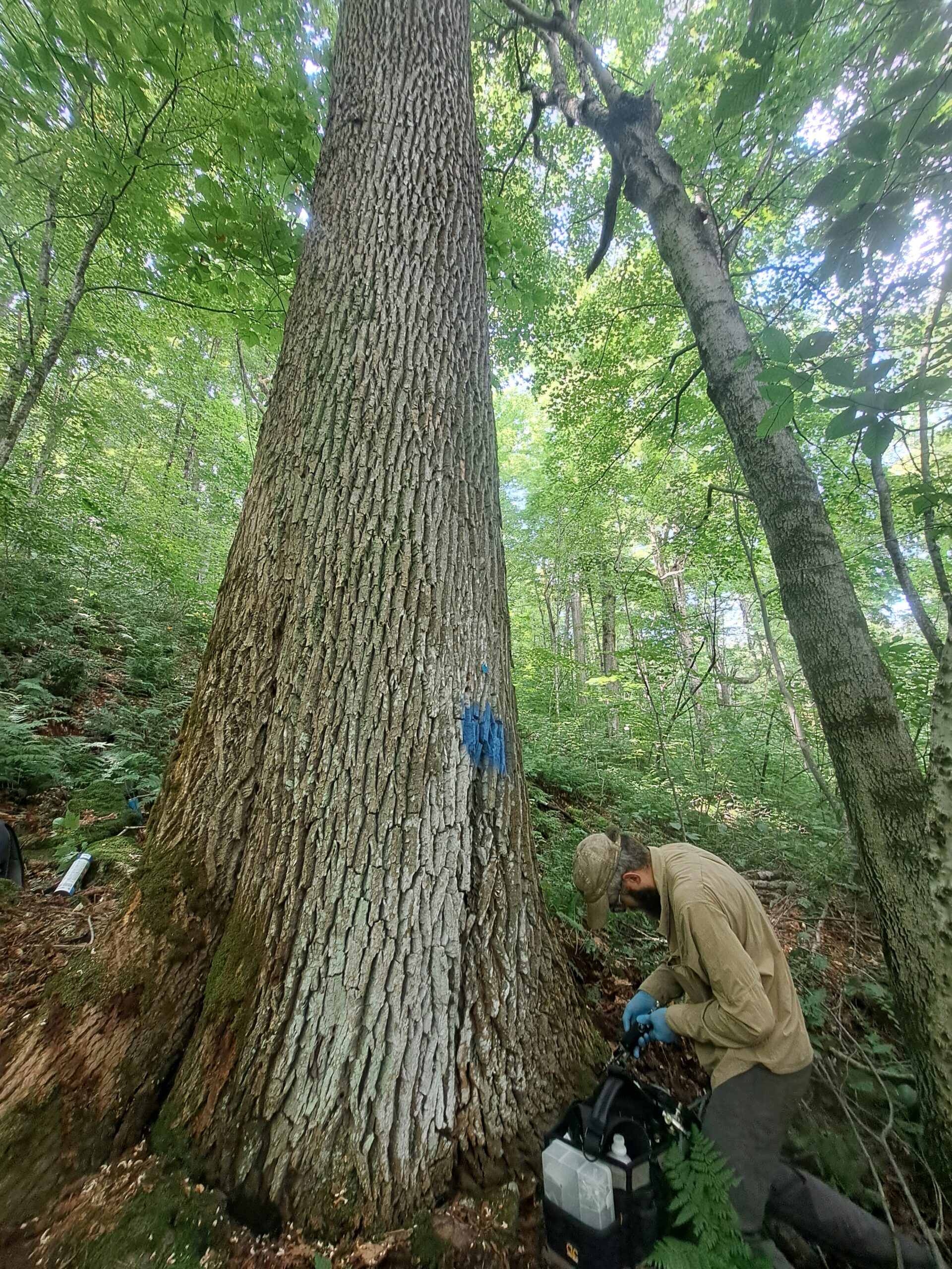
    GMC’s Senior Trail Technician, Matt Vezina, injects an Ash tree near Bennington with insecticide. Photo by Dan Hale.

    Dan Hale, ATC’s Senior Natural Resource and Land Stewardship Manager, says they chose these stands for their proximity to ecologically significant zone, and trail infrastructure like shelters. The treatment aims to both preserve ash tree genes for the future, and preserve biodiversity around the selected trees. Removal of a tree species can have adverse ecological effects in the surrounding area, especially on rare species and around vernal pools. So far, the treated stands include only white ash. But ATC would like to find suitable black ash candidates, and encourages hikers to report any black ash they find along the AT.

    Ash treated by ATC is identifiable by blue paint markings and metal ID tags. Every three years, Forest Service and ATC staff inject insecticide into a series of holes drilled around the tree’s base. The insecticide, emamectin benzoate, is considered safe for pollinators, because it is contained in the trees’ tissues (also, ash trees don’t attract bees). Technicians insert an arbor plug in each hole, essentially a one-way valve that retains the insecticide.

    Five milliliters of insecticide is injected per inch of tree diameter at breast height, with 10 milliliters injected per hole, rendering a tree toxic to emerald ash borer. The Forest Service and the ATC are encouraged by positive results that may allow lower doses in the next four-year cycle. Their efforts should help sustain these sylvan populations that could last indefinitely if other methods of controlling EAB are eventually developed.

    Have you seen any black ash on the southern LT or AT in Vermont? Please tell Dan Hale by email at

    Rowan Kamman joined GMC in 2025 as the new Land Stewardship Coordinator. He brings experience from other Northeastern nonprofits focused on conservation, stewardship, and education. The Long Trail and the Green Mountains have been important to Rowan since he could fit in a backpack. He will coordinate GMC’s volunteer corridor monitoring program, which maintains the boundaries of conserved lands along the Long Trail and the Vermont Appalachian Trail.

  • Big News for Strategic Conservation of the Long Trail System

    Big News for Strategic Conservation of the Long Trail System

    This article appears in the 2025 Spring Long Trail News and was written by GMC Director of Conservation Mollie Flanigan.

    In previous editions I’ve described the process of developing the Green Mountain Club Strategic Conservation Plan that outlines our road map to permanently protecting the Long Trail System. Plans are great, and strategic plans are even better, but even the best plan is quickly obsolete without the funding to implement it.

    Before we developed the strategic conservation plan, the club’s land protection effort focused on a few high priority properties that hosted the Long Trail. The strategic conservation plan brings a system-wide approach to GMC, and that has enabled us to bring our vision for landscape-scale conservation to the attention of the land conservation funding community. And last fall the club received an anonymous $250,000 grant to fund implementation of the plan!

    This means we can double our land conservation program effort for the next three years. It will enable us to lay the foundation for future land protection while still stewarding previously conserved land. We can shift from monitoring unprotected parcels and trying to act when properties go on the market, to a high-capacity and faster proactive approach to protecting the remaining vulnerable three percent of the Long Trail System.

    This spring we are hiring a full-time land stewardship coordinator to expand the capacity of the program. Our goal this year is to establish or reestablish relationships and develop individualized approaches for the owners of parcels that host portions of the Long Trail and its side trails designated as Tiers 1 and 2 in the plan. We will identify the number of actionable trail conservation opportunities on the 54 parcels, which total 12,866 acres, and are owned by individuals, towns or institutions. We will address Tiers 3 and 4 in years two and three. We aim to work on three conservation projects each year of the grant.

    The grant is a major advancement in GMC’s 39-year effort to conserve the Long Trail System. It includes a matching requirement, so we are working to identify more organizations and individuals interested in supporting this effort to protect the remaining 3 percent of the Long Trail System. We must raise $35,000 by 2026, another $67,000 by 2027, and $60,000 more by 2028.

    Thanks to steady support from members and donors like you, the club’s land conservation program is positioned to start putting our strategic conservation plan into effect. If you would like to be a part of this collective effort, please consider a gift. I look forward to writing more about progress on the plan in future editions of the Long Trail News.

  • Bingo! Play Along with GMC for Mud Season

    Was the latest snowstorm on your bingo card for mud season? Well, it was on ours. Check off boxes as you rack up your mud season experiences and try new ways to pass this messy time of year. Download a copy of the bingo sheet to play along: Mud Season Bingo

    Step in ankle-deep mud

    You’re definitely an optimist if stepping through mud isn’t on your bingo board. Here in VerMud, it’s pretty hard to avoid a messy boot moment like this, although we do hope ankle-deep moments are few and far between. One scenario where stepping through mud is smiled upon, however, is when hiking. Should you encounter mud and choose to continue (on an open mud-season-friendly low-elevation trail, of course), DO walk directly through it. The way through is messy, but helps prevent further mud season damage by avoiding widening the trail and trampling trailside vegetation. Read more: Everything You Need to Know About Mud Season in Vermont

    Go on a recommended mud season hike and check TrailFinder

    Mud season does place some limits on hiking as high-elevation trails and trails on state lands close, allowing them to dry out and protecting fragile alpine ecosystems. But there are still plenty of other parks and trails that remain open to enjoy. Popular mud season walking and hiking options include the Burlington Greenway, Stowe Recreation Path, Colchester Causeway, Mt. Philo in Charlotte, and Vermont’s four rail trails. But many town forests and trail systems also remain open to explore, as well as other less frequented trail options. Find more mud season hiking inspiration and recommendations, including staff favorites, scenic hikes, and accessible trails, on our Hike Recommendations page. And of course, we recommend exploring TrailFinder to find the open trails all around the state. Through it, you can find up-to-date information on which trails are closed, with updates made by the Department of Forest, Parks, and Recreation (FPR) every Friday.

    Spot the first spring ephemerals

    Painted trillium.
    Painted trillium.
    One of the most exciting aspects of mud season is being able to spot the first signs of spring plant life. As new growth begins to bring life and color back to the woods, keep an eye out for recognizable spring ephemerals. Spring ephemerals are wildflowers that bloom, set seed, and die back, all in the short period before the trees overhead leaf out and shade the understory of the forest floor. They provide an early season food source for pollinators like bees and flies. Keep an eye out for common spring ephemerals like skunk cabbage, trout lilies, trillium, and dutchman’s breeches.

    Join a spring trail work day

    After the winter months, the trails need some TLC before hiking season. The club’s membership sections each host several spring weekend workdays starting in late April and continuing through May. Spend a day with section volunteers, who have a wealth of knowledge on their local trail sections, and experience a bit of the work that goes into caring for the trails. The work you’ll perform will likely include clearing water bars to improve trail drainage, removing blowdowns, and trimming back branches and bushes along the trail. Find the calendar of section outings and work days here.

    Look out for migrating amphibians and returning bird species

    As plant life returns to the woods, so too does wildlife activity increase again. Amphibians like frogs and salamanders emerge from their overwintering sites and migrate to ponds, wetlands, and vernal pools to breed and lay eggs. During this migration period, you’re more likely to see more elusive amphibian species like spotted and blue-spotted salamanders, that are rarely seen until the following spring. Amphibians are vulnerable during this time as they cross roads near wetlands or ponds to reach breeding sites. Vermont Fish and Wildlife asks drivers to be cautious and drive slower in these areas, and report amphibian crossing locations if possible. Read how spring peepers, a type of frog well-known for their loud and high chorusing calls, survive through winter. Other wildlife species making their return in spring include birds like the red-winged blackbird, American robin, and the bobolink. These birds return from their fall migrations to the breeding habitats found here in the state, livening up backyards and woods with their activity – a sure sign of spring.

    Check and repair your gear ahead of hiking season

    Test it and check it before you go! As hiking season inches closer and you start preparing for those upcoming summer and fall adventures, check your gear. Is everything in working order? Are you missing or in need of any safety gear or the ten essentials? Several local Vermont outdoor retailers are GMC corporate sponsors and business members and a great place to either repair or acquire what you need.

    Watch pond skimming at a local ski resort

    Snowsports meet watersports in the event that is pond skimming. Many ski resorts hold their own high-spirited and often whimsical pond skimming events during the spring skiing period. Participants accelerate down a snowy run and use their speed, skills, and some amount of luck to try to successfully skim across a pool of water at the base of the run. Perhaps the most important element of pond skimming is the fun and festive costumes that are commonplace for participants to wear. Events in Vermont began in late March, but you can find upcoming April pond skimming events at a few resorts.

    Visit GMC’s new Visitor Center

    The club’s visitor center on Route 100 in Waterbury Center is open throughout mud season to help hikers find open and mud-season-friendly hikes and prepare for hiking season. Visit Wednesdays-Saturdays, or register for an upcoming workshop: Backpacking 101, Essentials of Map and Compass

    Enjoy local Vermont-made maple products

    Mud season coincides with Vermont’s sweetest season: sugaring season. Learn about the tapping and sugaring process at a local business (call individual businesses to confirm open hours) or celebrate this year’s crop of liquid gold at events like the Kingdom Maple Festival in St. Johnsbury or the Vermont Maple Festival in St. Albans. Sugarbushes that are open to the public also make a great place for a mud-season walk!

    Attend a GMC event or workshop

    It’s easy to feel antsy during mud season while waiting for the trails to dry and reopen. Fortunately, GMC has several spring events and workshops for you to add to your calendar, helping you embrace spring and prepare for hiking season. Join us to refresh or learn new backpacking skills, explore the logistics and experiences of an End-to-End Long Trail hike, and explore more of Vermont’s ecology. Registration is required, but most of these offerings are free and open to all interested hikers. Find the full schedule of upcoming events and workshops here.

    Share mud season guidelines

    Your own mud season actions play a big part in keeping the trails well-cared for and preserved for many more seasons of hiking. Help us spread word about how to steward the trails in mud season by sharing the message with friends and family and posting a friendly community reminder on your local Front Porch Forum. Thank you for doing your part to steward the trails throughout mud season!
  • Trail Talk: Waterbars and Drainage

    This article appears in the 2024 Fall Long Trail News and was written jointly by GMC’s Communications Manager Chloe Miller and Education and Volunteer Coordinator Lorne Currier. When Keegan Tierney, GMC’s Director of Field Programs, interviewed for his job in 2017, he said “You’ll never see me build a waterbar.” A few years later, Keegan admits that the legacy (read: steep) trails of the Long Trail System need thousands of these stone or log drainage channels, and installing, repairing, and clearing them is essential to managing the Long Trail System. So, what’s a waterbar, how does it work, what happens when one fails, and why are waterbars imperfect but necessary structures on Vermont’s steep and rugged trails? If you read the previous installment of “Trail Talk,” exploring the purpose and design of common trail features, you know trail builders try to keep people on trails, and water off them. In Vermont, those goals go hand in hand. A waterbar is a simple channel cutting diagonally across a trail, diverting surface water that would otherwise run down the trail (removing surface soil as it goes), and instead dispersing it into the woods. Like brush-ins, effective waterbars must be well-designed, built, and maintained to do their job of handling water and holding up to hiker traffic.

    In a Perfect World

    Waterbars work well when built and maintained properly, but they fail easily. If we were to start over and build the nearly 500-mile Long Trail System today, we would follow sustainable grades and use modern trail building techniques to avoid the need for so many waterbars. But our century-old trails often take the steepest route up a mountain. That’s, coincidentally, the same route water wants to flow down. Years of deferred maintenance means a good chunk of these waterbars are clogged or otherwise failing. And we must continually invest in better drainage for today’s and tomorrow’s extreme rainstorms.

    Building and Repairing Waterbars

    waterbars graphic A waterbar has a few components: The rock or log bar itself; the catchment area above it, where water is intercepted; the ditch conveying water off the trail; the apron, or drainage area where water spreads across the forest floor; and the dirt berm above and below the bar. On the Long Trail, most waterbars are built with rock, which is more durable than wood.  An effective waterbar extends well beyond each side of a trail, at least three feet into the surrounding forest, so a) water will not find its way back on to the trail and b) hikers are not tempted to step around the large stones of the bar in the middle of the tread. The ideal waterbar is set at a 45-to-60-degree angle across the trail, with stones arranged in a shingled manner so the upper ones overlap the lower ones. Rocks must be set securely into the tread and reinforced with crushed stone and mineral soil to keep them in place. The berm above the bar separates rocks from water, so that the base around the rocks doesn’t erode away. Waterbars can fail for a few reasons:
    1. The waterbar is too narrow, insufficiently hardened, and annoying enough that hikers go around it instead of over. This compacts the soil at either end of the waterbar, and allows water to find its way back to the trail. It can be prevented by extending the waterbar beyond the edge of the treadway and hardening its ends to make walking over the waterbar the easiest route.
    2. A rock in the bar is either too small or improperly set and becomes loose, creating a weak point for water to sneak past and travel down trail. In this case the waterbar will probably need to be rebuilt.
    3. Organic debris (leaves, sticks, trail sediment) fills the ditch and catchment area to the point that water overtops the bar and continues down trail. This is prevented by regular and thorough maintenance.
    Unfortunately, the large storms we now see so often can sometimes overtop the best waterbar.

    Critical Routine Maintenance

    Every fall, and after heavy rain, waterbars fill with fallen leaves and trail sediment. Then water can overtop the drain and rush down the trail, removing the trail surface as it goes. Overflowing waterbars have compounding effects, because they increase the volume of water the next downhill waterbar must handle. A big storm can wash out an entire trail from just one or two poor drains at its top. Caretakers and volunteer trail adopters perform the critical maintenance of cleaning waterbars, using trail tools like hazel hoes, mattocks, or even their boots or hands to move all organic material and accumulated sediment to the downhill side of the trail. They clear the drain down to mineral soil — the dense, durable, light-brown material beneath the easily eroded topsoil. Maintainers must ensure a smooth gravitational path for water; any upgrade or flat spot will cause water to pool and the waterbar to fail. If there are gaps in the stones of the bar, maintainers block them by a berm of mineral soil. They may alert GMC headquarters if reconstruction is needed. As rainfall becomes more intense, waterbars become more important, and good training of volunteers is vital.

    Noticing Waterbars As a Hiker

    Now that you understand waterbars, watch for them on your next hike. If it’s raining, watch them in action – diverting water from the trail – or failing, with water overtopping them and continuing down the trail. You can also help us reduce future maintenance needs by stepping up and over a waterbar, not around.
  • Rare Plant Discovery, A Win for Alpine Stewardship

    GMC caretakers walk up Mansfield ridgeline, stay on rocks
    GMC caretakers continue their alpine ID training along the Mansfield ridgeline. Photo by: Angela Hilsman
    This article previously appeared in the Spring 2023 Long Trail News under the headline “Alpine Steward Discovers Rare Plant on Mount Mansfield’s Summit.”  It was written by Liam Ebner. Alpine zones, the living remnants of the last ice age, make their home on the higher summits in New England and New York, where they serve as the refuge to endangered plants that have adapted to thrive in the harsh conditions there. In Vermont, less than 275 acres of this special tundra biome remain. Because the rare patches of alpine zone lie in beautiful and popular recreational areas, their plants face multiple dangers: climate change, development, invasive species, and the most immediate danger, human recreational impacts. In such austere conditions, survival is never guaranteed. However in 2022, the alpine zone welcomed back to the community a plant long considered extinct in Vermont.

    A Steward of the Alpine Zone

    My first experience in the alpine zone was hiking Algonquin Peak with friends in September 2020. New York has 173 acres of alpine zone, fewer than neighboring states, all concentrated in the Adirondack High Peaks like Marcy, Haystack and Algonquin. I knew these mountaintops were special, and I wanted to help protect them. I was fortunate to work as a summit steward for the Adirondack Mountain Club in 2021 between my junior and senior years of college at Rensselaer Polytechnic Institute in Troy, New York. After graduation, I returned to ADK for the 2022 season, educating hikers about the alpine zone, assisting in botany research, and maintaining trails above tree line in the High Peaks. In February this year, I became the Summit Steward Coordinator for the Adirondack Mountain Club, and am thrilled to continue working to protect this fragile ecosystem.
    Liam Ebner, Summit Steward for the Adirondack Club, talks with hikers on an alpine summit.
    Liam Ebner, Summit Steward for the Adirondack Club, talks with hikers on an alpine summit in the Adirondack Mountains.
    In October 2022, I attended the biennial Northeastern Alpine Stewardship Gathering co-hosted in Vermont by the Waterman Fund and the Green Mountain Club. The conference features professional presentations of alpine research and stewardship, and is a chance to engage with counterparts from New England, New York, and Canada to discuss challenges, trends, and successes. After two days of presentations, conference participants went on field trips to places with significant natural histories in Vermont. I joined a trip up Mount Mansfield led by Kevin Tolan, Staff Biologist at the Vermont Center for Ecostudies, to learn about the Bicknell’s Thrush (Catharus bicknelli), a rare migratory songbird that breeds in high elevation coniferous forests before migrating south to the Greater Antilles for the winter. Like alpine plants, the alpine and subalpine breeding habitats of the Bicknell’s Thrush are threatened by climate change. In October the chance of seeing this bird was slim, so I was also checking out some plants while on the summit ridge.

    Moment of Rediscovery

    Liam Ebner, Summit Steward for the Adirondack Club, on an alpine summit. At our turn-around point we chatted and took a snack break. Like any curious steward, I carefully explored, making sure to stick to bare rock while off trail. Plants in the alpine zone are extremely vulnerable to human impact: only a few footsteps can permanently damage or kill them. That’s why you’ll see white string delineating trail corridors on summits in Vermont and New Hampshire. It helps clearly guide people and dogs to stay on durable surfaces and concentrate their impact away from the most delicate plants. I noticed a small cluster of crowberry plants clinging to the soil and sprawling across the rock. In New York, two species of crowberry plants live in the alpine zone. The more common species, black crowberry, Empetrum nigrum, is abundant on most summits, and even grows on lower summits that would not normally be considered alpine (less than 3,500 feet in elevation). It’s common in Vermont as well.
    Black crowberry
    Black crowberry. Photo by: Angela Hilsman
    Purple crowberry, Empetrum atropurpureum, is much rarer in New York. It had not been seen in Vermont since 1908, causing biologists to list it as extinct in the state. While working in New York I picked up the habit of checking every crowberry plant, hoping to find more populations of the purple crowberry. Two major characteristics differentiate the two plants. Berry color is the most obvious. Purple crowberry sports purple fruit, while black crowberry bears black fruit. This enables easy identification, but only when there are berries. The plant on Mansfield had no berries, so I turned to the next trait. Black crowberry leaves grow from a bare red-orange stem, while the purple crowberry stem has the same color, but fine white hairs too. The Mansfield plant had white hairs, confirming it to be purple crowberry!
    Purple Crowberry. Photos courtesy of Glen Mittenhauser/Native Plant Trust

    What Does Purple Crowberry’s Reappearance Mean?

    Discovering a plant thought to be extinct in Vermont is extremely exciting. Not only is it great news for the biological community, it helps show that stewardship practices, such as GMC’s summit caretaker program, continue to help protect the alpine zone. The greatest danger for these plants remains hikers’ footsteps, but the greatest protectors are hikers themselves. You need not be an outdoor professional to help ensure plant survival. Just stick to marked trails, stay on bare rock, and practice Leave No Trace principles.
    Hikers on Mt. Mansfield ridgeline.
    Notice the stringing along the trail? Caretakers set that up to promote walking on rocks and off vegetation. Photo by: Angela Hilsman
    Vermont’s Fish and Wildlife department will monitor the health and growth of the purple crowberry and consider whether to include it on the state’s threatened and endangered species list. Next time you are on a high summit in Vermont or New York, ask a summit steward to show you some plants, and remember to do the rock walk! Liam Ebner is the Summit Steward Coordinator for the Adirondack Mountain Club. In his free time, he enjoys birding, paddling, and nature photography.
  • How Trail Crews Fight Erosion

    Stone stairs at Sterling Pond help curb erosion on a fall line trail.
    Stone stairs on the Sterling Pond Trail help curb erosion. Photo courtesy: Angela Hilsman
    “Erosion is what causes all the problems on trail,” says Kevin Hart, GMC field supervisor of the Long Trail Patrol. “The main goal of trail crew is to stop erosion.” Kevin’s not talking about bear encounters or overflowing privies or litter in firepits when he says “problems.” He’s talking about trail degradation. You know what that looks like: those deep gullies in the middle of the trail; widened, vegetation-less areas; and exposed roots and rocks. So what is erosion and how does it cause trail degradation? Kevin explained to his trail crew before the hiking season began with a quick demo. Follow along, as Kevin does a second demonstration to explain why erosion is a problem, why it’ll never go away, and how trail crews like the Long Trail Patrol upkeep and create sustainable trails.

    What is erosion?

    Erosion is the process of earthen materials (like soil and rock) being worn down and transported by natural forces such as wind, flowing water, or glacial ice. National Geographic has a great explainer here. “Erosion is always happening, but it’s happening so slowly that you can’t usually see it,” says Kevin.The exceptions are big storms and flash flooding, where a lot of water moves materials very quickly. As climate change increases the frequency and intensity of rain events, these will further expedite trail erosion. Looking into the next decade, climate change related storms are one of GMC’s biggest challenges.

    If erosion is normal, why is it a problem?

    Erosion can be particularly problematic around Vermont’s trail system because the Long Trail was built over a hundred years ago, long before sustainability was a consideration, says Kevin. “So many of our trails follow what’s called the fall line.” A fall line is the path that follows a mountain most directly downhill, he explains. And because it offers the least resistance, it’s also where water gathers. (Compare it to a switchback, or a trail that zigzags up the steep terrain instead of mimicking the slope.) “As the water channels along the fall line, it picks up speed, has more power, and causes more erosion,” explains Kevin. This exacerbates the wear-and-tear along Vermont’s Long Trail. Comparatively, when there is a switchback trail, the runoff water moves downhill in “sheets,” says Kevin. (Imagine flat and evenly dispersed.) Some of the water is absorbed into the relatively horizontal switchback trails, compared to funneling down the more vertical fall-line trails.

    How do trail crews stop this?

    Stone stairs and waterbars prevent erosion.
    Stone stairs and waterbars prevent soil erosion.
    “You can’t reverse erosion, but you can stop erosion on existing trails or build sustainable trails,” says Kevin. To stop water erosion, trail crews mainly use two methods: waterbars and stone stairs.

    #1. The Waterbar

    You’ve stepped over waterbars on trail: they’re the narrow drainage channels — usually fortified with rocks — that divert water off trail and into the forest. “[The water] ends up dispersing into the woods. It’s no longer stuck in a gullied path,” says Kevin. Trail crews and volunteers regularly clear waterbars of leaves and other debris to keep them working efficiently. Waterbars prevent water from following the fall line and lead the runoff to be absorbed by surrounding vegetation.

    #2. The Stone Stairs

    Rock stairs, which take the form of checksteps and stone staircases, create a durable surface. “Stone stairs are more resistant to erosion than dirt,” explains Kevin. “Water flows over the rock and essentially protects the trail surface. It keeps the gully [that exists] from deepening.” Stone steps have another benefit, says Kevin. Because they confine traffic to a durable surface, they prevent plants from getting trampled and encourage vegetation to return around the trail. Roots help anchor the soil in place, slowing erosion. These types of structures exist all over the Long Trail System; spot them on Stratton Mountain, the Sunset Ridge Trail up Mansfield, and the Monroe Trail to Camel’s Hump, says Kevin.

    Why can’t we reroute the trail to a more sustainable location?

    “A reroute is ideal, but it’s not as practical as it could be,” says Kevin. Sometimes barriers, such as private land or a ledge, prevent crews from moving the trail, he explains. More commonly, there’s not enough resources to reroute a trail.

    How can trail users help curb erosion?

    The best thing you can do as a trail user is to stick to the trail. Hiking around steep staircases, tree roots, mud puddles, and other trail features widens the path and increases trail erosion. The problem with a widened trail is twofold:
    1. Hikers disturb and kill off vegetation. Plant roots help anchor the soil in place, and without them, the soil becomes loose and easily picked up by runoff.
    2. Increased foot traffic compacts the soil, removing air pockets that water would normally seep into. When the rain and snowmelt cannot seep into the ground, it continues along the surface, picking up sediments as it goes.
    You’ll notice some of these issues on popular trails, like the Burrows Trail to the Camel’s Hump summit (which is currently getting a revamp). This steep, challenging trail tempts hikers to create their own routes; in doing so, trail users have widened the trail in areas. In doing so, water now has multiple paths to travel downhill, instead of the intended, durable path that trail crews designed.
  • What a Day Looks Like for GMC Caretakers

    Caretakers live onsite during their work weeks.
    Caretakers fold up a tent at Stratton Mt.

    This article previously appeared in the Spring 2021 Long Trail News under the title “Day in the Life of a GMC Caretaker.”

    As many more people than usual took up hiking last summer, the Green Mountain Club had to manage their impacts while making them feel welcome. Fortunately our caretakers can tap more than 50 years of experience educating and connecting with hikers while maintaining trails and overnight sites. Dozens of paid GMC caretakers live in the backcountry each season, helping hikers learn how to care for the special places they enjoy. This work, supported by your donations, keeps the Long Trail a world class hiking experience.

    Below, Nigel Bates takes us through a typical day in the life of a caretaker.

    A Caretaker’s Morning

    7:15 a.m.: I wake up on the caretaker bunk in Taft Lodge[1]. Most caretakers tent outside their shelters, but tenting is prohibited at Taft to protect the fragile subalpine ecosystem there. I sleep at Taft during my workweek, Thursday through Monday. On days off I leave the mountain and recharge at GMC headquarters in Waterbury Center.

    [1]In 2020 GMC did not station caretakers at Taft and Butler Lodges, to avoid the risk of COVID-19. We plan to resume staffing them this year, with appropriate precautions.

    7:30: After a few minutes to gather myself for the day, I climb down and make breakfast. I have to backpack my food to the lodge, so when I shop I choose lightweight but calorie- and nutrient-dense items. Today I opt for a big bowl of oatmeal with dried bananas, and plenty of maple syrup.

    As I dig in, I chat with a few thru-hikers about their plans. They’re headed south over Mount Mansfield to Puffer Shelter. I tell them about water availability, stress the ruggedness of the trail, and suggest Taylor Lodge as a fallback if they find themselves behind schedule.

    I learned the basics of trail maintenance, privy management and informal hiker education in a two-week preseason training, but like other caretakers, I learned the details of my range on my own.

    Lead caretakers pose for a photo.
    2019 Lead Caretakers: Taylor Radigan, Nigel Bates, McV LaPointe

    8:15: Once the hikers are off, I gather what I need for a morning on Mansfield’s summit. Some of the supplies are obvious: food, water, a Long Trail map, a first aid kit, and lots of extra layers. Others might surprise you! I never expected to carry a ball of cotton twine (to delineate the trail above treeline), a tally counter (to record the number of visitors to the summit), or an extra dog leash (in case someone arrives at the summit without one), yet all of these are essential components of my summit pack.

    8:30: I start up the Long Trail toward the summit. My commute, while only 0.6 miles, is some of the most difficult terrain of the trail. Fortunately I’m now intimately familiar with it!

    I arrive to find this morning’s thru-hiker friends basking in the sun and taking in the marvelous view from Vermont’s highest point. They’re in luck — more than half the time, the summit is enshrouded in clouds. I point out some of the main features: Mount Washington and Franconia Ridge to the east, Lake Champlain and the Adirondacks to the west, and the spine of the Green Mountains stretching south to Killington.

    White flowers of mountain sandwort, an alpine plant, on Mt. Mansfield
    White flowers of mountain sandwort, an alpine plant, on Mt. Mansfield. Photo by: Sheri Larsen

    Then I draw their attention downward to the alpine vegetation. These remarkable plants — diapensia, mountain sandwort, Bigelow’s sedge and others — survive on only a few of Vermont’s highest peaks, where harsh weather precludes trees. I remind them to step only on rocks above treeline to avoid trampling this fragile vegetation, a refrain I repeat countless times per day. Promising to do so, they continue their journey.

    9:15: A family of day hikers arrives. It’s a beautiful Saturday, so they are bound to be the first of many. I click my counter[2] four times as I say hello, and ask which trail they took. They hiked the Laura Cowles Trail, one of the more strenuous routes, and would like an easier way down. I recommend the Sunset Ridge Trail for stunning views as well as gentler terrain. I snap a family photo and remind them of the fragility of the alpine vegetation. They, too, promise to stay on rocks.

    [2]Caretakers count hikers so the club can chart trends from year to year, and devise trail management strategies accordingly.

    Caretakers engage hikers, especially on busy days like this one on Mt Mansfield.
    Busy summit on Mt. Mansfield. Photo courtesy: Michael Dillon

    10:30: The summit is getting busy, so it’s time for a trash sweep. Caretakers lead by example, whether on duty or off, so we try to clean up while hikers are watching. As I crisscross the summit with my trash bag (staying on the rocks, of course), I talk with visitors about how we can all help keep the mountain clean. There are always many new hikers, and we strive to introduce them to the principles of trail stewardship in a welcoming and inclusive way. We hope to inspire all visitors, new or experienced, to pack out their trash, and maybe even some left by others!

    11:00: A man arrives and begins to set up a drone. I walk over, say a friendly hello, and ask him to refrain from flying the drone on the summit.

    “Why not?” he asks, a bit irritated. I explain that drones have a negative impact, not only on other hikers but also on birds. On cue, a peregrine falcon appears overhead and dives into Smuggler’s Notch. We’re both awestruck. As he puts the drone away, I thank him for respecting the wildlife that call Mansfield home. This was an example of soft stewardship: taking an opportunity to make hikers aware of the impacts of their actions and empower them to make good decisions.

    A Caretaker’s Afternoon

    12:30 p.m.: My summit shift is almost finished, and another caretaker arrives for the afternoon. Since it’s so busy we work together for a while to make sure everyone stays on the rocks while they eat lunch. When the rush subsides, I leave for some trail maintenance lower down the mountain.

    1:30: With more than 10 miles of trails in my range, there are always plenty of tasks. Today I decide to clip the corridor on the Hellbrook Trail. Corridor maintenance is a delicate balance: too narrow, and hikers are hit in the face with annoying branches. Too wide, and hikers tend to trample vegetation on the edges of the trail. I clip conservatively here to preserve delicate mosses and bunchberries along the path.

    Compost run on Glen Ellen
    Nigel stirs compost at Glen Ellen.

    3:30: I rush back to stir the composting run at the privy at Taft. Once a week I spend an hour digging into the pile with a spading fork to break up clumps and redistribute the mixture of waste and bark mulch for another cycle of heating. I explain to a curious group of teenagers that because Taft is such a popular site, it generates a lot of human waste, so we use high-temperature composting to speed the process. We all agree that the process is kind of gross, but also kind of cool.

    A Caretaker’s Evening

    5:00: After dousing myself in hand sanitizer, I hike out to the Adam’s Apple for a few minutes of solitude before overnight hikers start arriving. Caretaking is a full time job, and while I love interacting with people, it’s important to find time to recharge and remember why I’m out here in the first place. The dramatic views of Lake of the Clouds and Smuggler’s Notch never fail to blow me away.

    Nigel takes a breather on Camel's Hump.
    Nigel takes a breather on Camel’s Hump.

    6:00: As it enters its second century, Taft Lodge welcomes a new generation of hikers. This evening while backpackers stream in I orient them to the privy, water source and washpit, gently reminding them of Leave No Trace principles as needed. As stewards of the backcountry, caretakers and hikers new and old should pass along our principles with kindness and respect.

    Soon enough the sun goes down, chatter subsides, and hikers retire to sleeping bags. I climb to my bunk and join them in slumber. I’m tired, but it’s a good fatigue, the kind you feel after a long day making a difference. Tomorrow I’ll wake and do it all again. But every day on Mansfield is a little different, and I look forward to seeing what tomorrow will bring.


    From May through October Green Mountain Club backcountry caretakers from Stratton Mountain to Sterling Pond spend their days protecting ponds, summits and trails while helping the hiking public get more from their time in the Green Mountains. This rewarding and vital program is possible only through your support through memberships and donations. You enable each caretaker to protect the backcountry, and to welcome and inform the hiking public.


    Nigel Bates started with the GMC as Mansfield Lead Caretaker in 2019 and is now entering his second season supervising the caretaker program.

  • Leverage: It’s Not About Size or Strength

    This article was written by Rosalie Sharp, 2019 Long Trail Patrol Leader, and previously appeared in the Fall 2019 Long Trail News.

    Family and friends typically struggle to understand what I mean when I say I lead trail crews. I’ve found the quickest way to create an image is to tell them something like “My crew and I find boulders in the woods, move them onto the trail, and set them in the ground to make structures that prevent erosion.”

    That’s a simplification for sure, since we do more than stonework, but it fairly represents most Long Trail Patrol projects. Vermont trails are often steep, rocky, muddy, or some combination thereof. Stone structures are usually the best way to concentrate hiking traffic on a durable and well-drained surface. And ‘boulders’ is no understatement—the rocks we use are truly massive.

    How can a crew of four move such big rocks? With the right tools! Generations of trail builders have moved boulders with hand tools since Long Trail construction began. The Long Trail Patrol continues to use rock bars and pick mattocks almost daily. While rigging systems help bring rocks to the trail, the rock bar and the pick are the most essential tools. We could do any of this season’s stone projects with just them and a sledgehammer. They’re simple, but powerful.

    Of course, they must be wielded effectively. A bar rightly placed can flip rocks no human could budge with muscle alone. Physical strength is an asset, but it’s not the most important one. Using tools wisely, we can lift heavier loads, with less strain. That’s essential for anyone hoping to do trail work for more than a couple years, and to avoid back problems before 30.

    A rock bar is simply a lever. Placing the beveled end under a rock and prying up or down gives a worker substantial mechanical advantage. The closer the rock to the fulcrum, and the farther away we grip the bar, the less force we need to move the rock.

    As a worker starts rolling a big rock, they can lift only so far before the bar must be repositioned for another lift. This requires teamwork: another crew member places a bar to hold or move the rock further while the first person repositions. They take turns until the rock flips, then repeat the process. When the rock nears its final location, workers must plan their movements to place the rock properly in the hole they’ve dug, all of which requires foresight, precision, and a good sense of how that rock will behave.

    Which brings me to the pick mattock, which is a combination lever and digging tool. The mattock end can dig a rock out of the soil, moss, and leaves where it starts, and also dig the hole in the trail where it will finish. The pick end is the lever. However, because the handle is perpendicular to the pick, using a pick instead of a bar requires forces in different directions. Workers usually use a bar to move rocks up and away, but a pick works best to move rocks up and toward a worker. Predicting the forces to apply to our tools enables us to move rocks through the woods efficiently, accurately, and safely.

    Building skill and confidence with these tools can be incredibly rewarding. Last summer I approached three Green Mountain Club volunteers struggling to lift a rock the size of a tractor tire from a deep, boggy section of soil. Their rock bars kept slipping through the mud, deer flies buzzed above, it was at least 80 degrees, and they were understandably tired and frustrated. “We’re not strong enough to move this rock,” they declared.

    But they were strong enough. What they needed was strategy. We set smaller rocks for fulcrums so our bars wouldn’t slide through the mud; we planned where to place our bars; and we focused on communicating clearly. Within 20 minutes we had that rock flipped out of the hole, and they were rolling it down to the trail with renewed energy and confidence.

    Those three volunteers were women. Unfortunately, their belief in weakness is common among women new to trail work. Women trail workers often, though not always, have less upper body strength than many men, so they tend to feel less capable. That’s how I was at first, but I’ve been fortunate to work with extraordinary women who showed me that small size and limited strength need not be a disadvantage. I’ve never been very good at moving rocks by hand, but that pushed me to learn how to choose and use the right tools. I’m much stronger now than when I began rock work, and choose using tools over my hands most of the time. I’m a faster, safer, and healthier trail worker because of it.

    Nearly every stone structure on the Long Trail was built with rock bars and pick mattocks, and many have lasted decades. The tools are timeless, simple, and essential to working on Vermont trails. Long Trail Patrol crews will be using them all over the Green Mountains this season. Come, find us, and see some rock moving in action!